
ADVERTISEMENTS:
In this article we will discuss about:- 1. Introduction to Sedimentation in Reservoir 2. Distribution of Sediments in Reservoir 3. Factors Affecting Sediment Distribution Pattern 4. Predication 5. Factors Affecting Reservoir’s Sedimentation 6. Rates 7. Measured Rates 8. Reservoir Sedimentation Control.
Contents:
- Introduction to Sedimentation in Reservoir
- Distribution of Sediments in Reservoir
- Factors Affecting Sediment Distribution Pattern
- Predication of Sediment Distribution
- Factors Affecting Reservoir’s Sedimentation
- Rates of Reservoir Sedimentation
- Measured Rates of Reservoir Sedimentation
- Reservoir Sedimentation Control
1. Introduction to Sedimentation in Reservoir:
ADVERTISEMENTS:
The integrated development of river basin also involves the construction of water storage bodies, i.e. the reservoir for rain water harvesting to solve the problems of irrigation, power generation, flood control etc. The sedimentation is one of the main problems with the water storage structures.
It should be essentially considered in the design and maintenance of these structures, because deposition of sediments in the reservoirs reduces their net storage capacity. The sedimentation in the reservoir gets start as the river water enters the storage area, because of reduction in entering flow velocity due to increased cross-sectional area of the flow.
In course of sedimentation if water which was already stored in the reservoir is clear and the inflow is muddy, then these two fluids of different densities involve different velocities, in which the turbid water tends to flow along the bed towards dam due to gravity force; this type of flow is referred as stratified flow, and the under flow is called density current. Basically, the density currents are the gravity flow. The process of sediment deposition in the reservoir refers to the reservoir sedimentation.
In reservoir design, the allowance for deposition of sediment must be given. The volume of reservoir which is to be used for irrigation, power etc., is called live storage; it should be fixed after providing allowance for sediment deposition. It is very common that the major portion of sediments are deposited in the area of live storage, which greatly affects the functioning of the reservoir.
ADVERTISEMENTS:
2. Distribution of Sediments in Reservoir
:
ADVERTISEMENTS:
The sediment distribution pattern in the reservoir is an important consideration in planning and design of reservoirs.
Its significances are mentioned below:
1. It provides an idea that, how the sediments tend to deposit near the dam during a given time period, on the basis of which the position of outlet to be fixed for letting out the water and penstock gates etc., is decided.
ADVERTISEMENTS:
2. The allocation of various storages in reservoir is also carried out on the basis of distributed pattern of sediments in the reservoir.
3. It helps to determine the region of delta formation in the reservoir, and thereby the increase in back water level.
4. The sediment distribution pattern also decides the sites for locating the recreational facilities such as swimming, boating etc.
3. Factors Affecting Sediment Distribution Pattern
:
The sediment distribution pattern in the reservoir depends on many factors, described as under:
1. Slope of Stream:
In the reservoir connected with the stream having steep slope and long reach, the deposition of sediment takes place in lower portion of the reservoir to a large extent. On the other hand, when connecting stream has mild slope and smaller reach to the reservoir, then siltation takes place at higher elevations of the reservoir.
2. Reservoir Length:
The length of reservoir affects greatly the sediment distribution in it. On the basis of several observations, it has been reported that the large size sediments get deposit in the lower portion of the reservoir for a shorter length, but the smaller sediments are deposited at higher elevations for longer length.
ADVERTISEMENTS:
3. Reservoir Constriction:
If there is constriction in the reservoir, then deposition of sediment takes place in the upper portion, comparatively in large proportions. The sediment deposition pattern is flatter in constricted portion, and does not follow the natural slope.
4. Size of Sediment:
The sediment size is concerned it ranges from fine to large boulders. It greatly affects the pattern of sediment deposition in the reservoir. For example if there is large proportion of big size sediments, then at lower elevations there would be greater deposition. While if fine particles are more, then there would be more deposition near the dam of the reservoir.
5. Inflow Capacity:
The inflow capacity plays a great role in sediment distribution pattern of the reservoir. In a small reservoir governed by large size river, passes most of the finer particles along the inflow very quickly into the storage area, but they do not get time to settle down in the reservoir, but they are disposed off towards downstream. In bigger reservoirs, the water retains for a long time, which results into complete deposition of suspended sediments.
6. Reservoir Operation:
The reservoir operation technique greatly affects the pattern of sediment deposition. The reservoir may be operated for single purpose and multipurpose, both. The single purpose reservoir operations are generally performed at constant level, and as such the primary pattern of sediment deposition is not much affected.
But in case of multipurpose reservoirs, the operation is conducted in a wide range to fulfill various demands throughout the year, which causes a significant variations in the primary sediment distribution pattern. The possible reason may be flushing of deposited sediments from live storage of the reservoir.
7. Inflow Pattern of the Stream:
A stream, in which flood takes place in the early of the monsoon, the amount of sediment reaching into the reservoir is being more, which settle down in the reservoir. On the other hand, when major flood occurs at the end of monsoon period, then a reverse trend is observed in sediment deposition.
8. Vegetal Growth:
The vegetal growth in upstream area of the reservoir or in nearby areas, helps in trapping the sediments and thus reducing the entry of silts amount into the reservoir, as result the sediment distribution pattern is also affected, accordingly.
9. Sediment Load in River Flow:
The amount of sediment load carried by the river flow varies greatly both in quantity and quality, depending on the watershed characteristics in regard to the land use and climatic conditions. In addition, the trapping of sediment also depends on retention period, which is reduced with the age of reservoir. The sedimentation pattern is also affected by these variations in the reservoir.
10. Shape of Reservoir:
The shape of reservoir also plays a key role on sediment distribution pattern. For example – in the reservoir of regular shape, the suspended sediments tend to deposit uniformly over the bed along the direction of flow, with decreasing depth away from the dam. But there would be a large variation in the depth of sediment deposition at the bottom, if the shape of reservoir is irregular.
11. Outlet:
The outlet of reservoir, if has adequate capacity and is located at lower elevation, then the density current tends to pass out very rapidly, as result the deposition of sediments from the density current near the dam, gets affected.
12. Sediment-Reservoir Volume Ratio:
If the volume of sediment inflow is more as compared to the passing out sediments from the reservoir, then sedimentation takes place in large extent; and in this condition the reservoir has very short useful life.
4. Predication of Sediment Distribution:
A host of methods have been introduced by several scientists for predicting the sediment distribution pattern in the reservoir. Borland and Miller (1960) have introduced two different methods – in which one is the Area-increment method and other is the Area-reduction method for predicting the distribution pattern of sediment. These methods are applicable to large and multi-purpose reservoirs. Heineman (1961) also developed a method for determining the depth of sediment accumulation near the dam, and also for locating the spillway in small water retarding structures.
1. Area Increment Method:
This method is based on the fact that the deposition of sediments in the reservoir causes reduction in the storage area of reservoir. The amount of sediment deposition is considered as a constant amount called area correction factor, which is usually equal to the original elevation up to which dam is completely silted. In this method, the amount of sediment deposition is calculated on the basis of reduced area.
The area is computed by using the prismoidal formula or end-area method. The area reduced by silt deposition, is adjusted by increasing the area of reservoir. The increment area of reservoir should be such that the capacity below maximum level is equal to the pre-determined capacity.
The formula used for determining the sediment distribution in reservoir under this method is given as under –
Vs = Ao(H – ho) + Vo … (24.1)
Where,
Vs = volume of sediment deposited in the reservoir (ha.m)
Vo = volume of sediment deposited below new zero elevation (ha.m)
Ao = area correction factor (ha) which is equal to the original reservoir area at new zero elevation.
H = reservoir depth near the dam, measured from the stream bed to the full reservoir level (m)
ho = depth of sediment to which reservoir is filled up to new zero elevation (m)
This equation states that the total sediment deposition volume Vs is uniformly distributed for the height (H – ho) plus the depth below new zero elevation of the reservoir. Computation of total volume of sediment (Vs) can be done by using the original area-capacity curve of the reservoir.
2. Area-Reduction Method:
This method was developed based on the analysis of sediment distribution data obtained from several reservoirs. A series of curves of sediment deposits for different types of reservoir, namely – (1) gorge, (2) hill, (3) flood plain-foot hills, and (4) lake was developed by Borland and Miller (1960) to determine the values of constant, required for computation of the design curve. The curve is given as –
![]()
Where,
Ap = dimensionless relative area at the distance ‘p’ above the stream bed.
Cp, m & n = constants; their value depends on the type of reservoir. These are dimensionless.
This method provides more reliable result than the area-increment method.
3. Elevation of Sediment-Accumulation Methods:
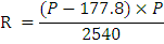
Heineman (1961) developed a mathematical relationship using regression technique, on the basis of sediment distribution studies of different reservoirs. He also mentioned that the minimum depth of sediment accumulation takes place immediately at upstream side of the dam. The equation could be expressed as –
Y = 22.6 + 0.886D – 81.2b – 0.175c + 0.494w … (24.3)
Where,
Y = original depth filled with sediment (%)
D = depletion in original stage at the end of design period (%)
b = slope of curve drawn between depth and capacity of the reservoir on log-log paper.
c = storage capacity remained at the end of the design period (acre-ft.).
w = specific weight of the sediment (1b/ft3).
4. Trigonometric Method:
This is a graphical method for predicting the sediment distribution. It is suitable for small reservoirs up to 300 million m3 capacity. The curves of original capacity and capacity after siltation of the reservoir are required for drawing the rays on original capacity curve, from the ordinate of maximum reservoir level.
The length of each ray is reduced in the proportion of ratio of resultant capacity to the original capacity of reservoir. The curve obtained by joining the points of reduced length of different rays, is the resultant capacity curve. This curve can be used for predicting the sediment distribution pattern in the reservoir.
5. Observed Pattern of Distribution Method:
This method is based on the long-term reservoir sedimentation data. The following empirical relationship has been developed to predict the distribution pattern of sediment for different types of reservoir –
S = K.Cn … (24.4)
Where,
S = percent sediment deposited capacity of the dead storage of reservoir
C = percent dead storage volume of the total storage volume of the reservoir
K & n = constants; depend on the reservoir’s type. The values of K and n are given in Table 24.1.
5. Factors Affecting Reservoir’s Sedimentation
:
The different factors involved to affect the silting of reservoirs are described as under:
1. Quality, quantity and concentration of sediments in the river flow, entering the reservoir.
2. Amount of silt intercepted at the upstream part of the reservoir from the runoff that is to be stored into the reservoir, also affects the reservoir sedimentation.
3. The deposition of silts into the reservoir also depends on the methods of reservoir operation, nature of spillway and other discharging arrangements used in the reservoir.
4. Amount of silt per unit runoff volume coming into the reservoir.
5. Reservoirs length.
6. Total runoff volume and peak discharge from the watershed.
7. Ratio of runoff volume to the reservoir capacity.
8. Nature of sediment materials entering the reservoir.
9. Depth and age of deposited sediments in the reservoir.
10. Size and shape of watershed also affect the reservoir sedimentation, because the rate of sediment production gets decrease with increase in the watershed size, and vice-versa.
11. Slope of the watershed tends to increase the flow velocity, thereby a large amount of silt is changed into the reservoir.
12. Vegetative growth at the reservoir head decreases the soil erosion; and thus, siltation is also reduced, accordingly.
13. Soil characteristics of catchment area affect the sedimentation. Clay soils are comparatively less erodible than the silty and sandy soils. Similarly, a dry soil is more erodible than, the moist soil. Igneous rocks are not easily erodible than the sedimentary or metamorphic rocks. Since, the soil erosion is the source of sediment yield, therefore, silt deposition in water bodies gets affected, according to the soil types.
14. Type and form of rainfall affect the sediment yield from the watershed. A high intensity rainfall of short duration yields peak runoff, and more silt is added to the stream flow. Normally, large amount of sediments are produced in monsoon season due to intense storms.
15. Effective annual rainfall of the watershed.
16. Degree of mean monthly and mean annual temperature of the watershed.
17. Unforeseen causes such as earthquake etc., generate additional amount of silt load. During earthquake a large amount of debris is displaced and transported by the rivers, which are ultimately reached to the reservoirs, and get deposited there.
6. Rates of Reservoir Sedimentation:
The rate of reservoir sedimentation is predicted by using various methods; few of them are described as below:
1. Annual Rate of Deposition:
The design of Indian reservoirs is based on the annual silting rate of 0.036 Mm3 per 100 sq.km area of catchment (Khosla’s recommendation), but as per recent survey on silting rate of some reservoirs revealed that, the actual silting rate is much higher than 0.036 Mm3/100 Km2. The annual rate of silt deposition in the reservoir can be computed by using the following formula –
![]()
Where,
Sa = annual rate of silt deposition in acre-ft.
W1, W2… Wn = incremental area of watershed effective to each erosion rate, acres.
A1, A2 . An = erosion rates, tones/acre.
DRe = delivery ratio, percent.
Te = trap efficiency of the reservoir, percent.
S = specific weight of sediment, lb/ft.3
The sedimentation rate is expressed in terms of percent of annual capacity of reservoir lost. It can be determined by using the following formula –
![]()
In which, S is the annual loss of reservoir’s capacity expressed in percent; Sa is the annual deposition of silt and C is the reservoir capacity.
2. Joglekar’s Method:
This method follows silt enveloping curve for predicting the annual rate of sedimentation in the reservoir. The curve is given as under –
![]()
Where,
Y = annual silting rate, (Mm3/100 sq. km)
A = catchment area of the reservoir, (sq.km)
This enveloping curve indicates that the rate of sediment deposition in the reservoir gets decrease as the catchment area increases.
3. Regional Enveloping Curve Method:
Varshney and Raichur have developed following enveloping curves for following cases:

7. Measured Rates of Reservoir Sedimentation:
The factors to affect the rate of soil detachment from the soil surface; transportation of eroded materials to the reservoir and trapping of the sediments in the reservoir, are complex and highly variable. They vary from place to place, depending on the geology of the area reflecting the characteristics such as slope, and rainfall and runoff as the hydrologic characteristics and cover conditions.
All these factors cause a wide variation in the rates of erosion and sediment transport from the watershed to the reservoir. The reservoirs capacity per unit drainage area also affects the silt deposition. Therefore, the aerial extent of drainage basin should be fully considered to carry out better reservoir design.
8. Reservoir Sedimentation Control:
In order to increase the reservoirs life, it is very essential to control the problem of sedimentation, i.e. deposition of sediments in the reservoir.
The measures which are followed to control the reservoir sedimentation are classified into following two parts:
1. Pre constructive measures; and
2. Post constructive measures
1. Pre Constructive Measure:
It refers to those measures which are used before and during execution work of the reservoir construction.
These measures can be enumerated by the following points:
i. Selection of Dam Site:
The amount of sediments reaching to the reservoir from the catchment area, depends on the soil erosion caused by water. If the catchment area is less susceptible to erosion, then less silts are charged into the stream flow, as result reservoir siltation gets reduce. Thus, sedimentation can be reduced by selecting a suitable reservoir site. That site is more appropriate, where least soil erosion is taking place.
ii. Design of Reservoir:
The design of reservoir plays a significant role in the reservoir sedimentation. If the storage capacity is less than the volume of stream flow coming into the reservoir, then a large volume of water will be passed out from the reservoir, as result there is reduction in the silting rate as compared to the situation when the entire water is stored.
The life of reservoir can be prolonged by constructing the reservoir’s dam in various stages. In other words, initially the dam should be built for lower height, and raised subsequently according to the volume of reservoir has been silted up.
iii. Construction of Check Dam:
Check dams play a key role in controlling the inflow of sediment into the reservoir. The check dams are constructed across the stream/river, delivering the major portion of sediment load. These dams trap large amount of coarser sediments.
However, the construction of check dam for the purpose of sediment control is quite expensive, hence not commonly used, but the growing of vegetation in u/s area of the reservoir is most suitable and is preferred to trap the sediments.
iv. Installation of Vegetative Screen:
Vegetative screen is the vegetative cover through which flood water passes before entering the reservoir. The control of sediment to a reservoir by means of vegetative screen is based on the principle of trapping the sediments by reducing the flow velocity and filtering the soil particles from the flood water. It is one of the best and cheapest methods of silt control.
v. Construction of Sluice Gate in Dam:
There must be provided the provision of sluice gate at the base of the reservoir dam, to remove the silted water from the reservoir. Since, the sediment concentration is more at the bottom of the reservoir, therefore, the sluice gates should be located at the lower portion of the dam.
This method is not much suitable, because the flow of water tends to make the channel behind the sluice, from which the water flow takes place, as result most of the sills get undisturbed.
It is very essential, that the release of sediment from the reservoir through sluice gate must be simultaneously supplemented by the mechanical loosening and scouring of neighbouring sediments to increase effectiveness. However, this method has structural problem, hence not widely used.
vi. Reservoir Operation:
The sediment delivery rate increases with increase in the rate of water discharge. The discharge rate of reservoir depends on the water demand of the command area. The amount of sediment trapped by the reservoir for a given drainage area gels increase with increase in its capacity.
The sedimentation rate decreases with the reservoir’s use. The ratio of reservoir capacity and size of the drainage basin, is one of the most important factor affecting the annual rate of sediment accumulation in the reservoir. This ratio should be less than unity.
vii. Erosion Control:
Soil erosion in u/s catchment is the main source of sediment yield. To control sedimentation problem, the control of erosion is most essential. The erosion control measures include all those practices which are effective in preventing or delaying the movement of sediment laden flow from the origin point in the drainage basin lo the reservoir. Vegetation is an effective method to reduce the sediment flow into the reservoir as compared to the other erosion control measures such as check dams etc.
2. Post-Constructive Measure:
Post constructive measures are used during reservoir operation.
It includes following methods for controlling reservoir sedimentation:
i. Removal of Flood Water:
It is well known that the sediment content is more in the stream water during initial phase of the flood. Therefore, this phase of flood water is not allowed to collect into the reservoir.
ii. Stirring of Sediment:
It is generally performed by mechanical stirrer. In this work, the deposited sediment is scoured and mixed in the water, which is flushed outside through the sluice gates.
iii. Removal of Silt Deposits:
The deposited sediments in the reservoir are also removed by excavation, dredging and sluicing with hydraulic or mechanical agitator. Dredging method is most expensive among all, and is not economically viable for all the water storage bodies.