ADVERTISEMENTS:
In this article we will discuss about:- 1. Meaning of Runoff 2. Types of Runoff 3. Factors Affecting Runoff 4. Runoff Cycle 5. Computation.
Meaning of Runoff:
Rainfall is the primary source of water for runoff generation over the land surface. In common course of rainfall occurrence over the land surface, a part it is intercepted by the vegetations, buildings and other objects lying over the land surface; and prevent to reach them on ground surface, called interception. Some part of rainfall is also stored in the surface depressions, referred as depression storage, which in due course of time gets infiltrated or evaporated.
When all these losses are satisfied, then excess rainfall moves over the land surface and reaches to the smaller rills, known as overland flow. The overland flow again builds a greater storage over the land surface and draining the same into channels/streams is termed as runoff.
ADVERTISEMENTS:
Thus, runoff may be defined as that portion of rainfall as well as any other flow, which makes its way towards the river, stream or oceans etc. Since, runoff is through the channel, stream/or rivers etc., therefore, sometimes it is also called as channel flow.
Types of Runoff:
Based on the time delay between the instance of rainfall and generation of runoff, the runoff may be classified into following three types:
1. Surface Runoff:
It is that portion of rainfall, which enters the stream immediately after the rainfall. It occurs, when all losses are satisfied and if rain is still continued with the rate greater than the infiltration rate; then excess water makes a head over the ground surface (surface detention), which tends to move from one place to another following land gradient, is known as overland flow. As soon as the overland flow joins to the streams, channels or oceans, is termed as surface runoff.
2. Sub-Surface Runoff:
ADVERTISEMENTS:
That part of rainfall, which first enters into the soil and moves laterally without joining the water-table to the streams, rivers or oceans, is known as sub-surface runoff or inter flow. Sometimes sub-surface runoff is also treated under surface runoff due to reason that it takes very little time to reach the river or channel in comparison to ground water. The sub-surface runoff is usually referred as interflow.
3. Base Flow:
It is delayed flow, defined as that part of rainfall, which after falling on the ground surface, infiltrates into the soil and meets to the water-table; and flow to the streams, oceans etc. The movement of water in this type of runoff is very slow, that is why it is also referred as delayed runoff. It takes a long time to join the rivers or oceans, say for as years. Sometimes, base flow is also known as ground water flow.
ADVERTISEMENTS:
Thus,
Total Runoff = Surface runoff (including sub-surface runoff) + Base flow
Factors Affecting Runoff:
The runoff rate and its volume from an area, mainly influenced by the following two factors:
The climatic factors of the watershed affecting the runoff are mainly associated to the characteristics of precipitation, which include:
1. Type of Precipitation:
Types of precipitation have great effect on the runoff. For example, a precipitation which occurs in the form of rainfall, gets start immediately to flow in form of surface flow over the land surface, depending on its intensity as well as magnitude, while a precipitation which takes place in the form of snow or hails, the flow of water on ground surface does not take place immediately, but after melting of the same. During the time interval between occurrence and their melting, the melted water infiltrates into the soil and results a very little surface runoff generation.
2. Rainfall Intensity:
The intensity of rainfall has a dominating effect on runoff yield. If rainfall intensity is greater than the infiltration rate of the soil, then the surface runoff takes place very shortly, while in case of low intensity rainfall, there is found a reverse trend of the same. Thus, high intensities rainfall yield higher runoff and vice-versa.
ADVERTISEMENTS:
3. Duration of Rainfall:
Rainfall duration is directly related to the volume of runoff generation due to the fact that the infiltration rate of the soil goes on decreasing with the duration of rainfall, till it attains a constant rate. As result of this, even a mild intensity rainfall lasting for longer duration may yield a considerable amount of runoff.
4. Rainfall Distribution:
Runoff magnitude from a watershed depends very much on the distribution of rainfall. The rainfall distribution for this purpose is expressed by a term “distribution coefficient”, which is defined as the ratio of maximum rainfall at a point to the mean rainfall of the watershed. For a given total rainfall, if all other conditions are the same, then greater the value of distribution coefficient, greater will be the runoff and vice-versa. However, for the same distribution coefficient, the peak runoff would be resulted from the storm falling on the lower part of the basin i.e., near outlet.
5. Direction of Prevailing Wind:
The direction of prevailing wind affects greatly the runoff flow. If the direction of prevailing wind is same to the drainage system then it has a great influence on the resulting peak flow and also on the duration of surface flow to reach the outlet. A storm moving in the direction of stream slope, produces a higher peak in shorter period of time, than a storm moving in opposite direction.
6. Other Climatic Factors:
The other climatic factors such as temperature, wind velocity, relative humidity, annual rainfall etc., affect the water losses from the watershed to a great extent; and thus the runoff is also affected, accordingly. If the losses are more, then runoff will be less; and vice-versa.
(B) Physiographic Factors:
Physiographic factors of watershed consist of both the watershed as well as channel characteristics.
Different characteristics of watershed and channel which affect the runoff, are listed below:
1. Size of Watershed:
Regarding size of watershed, if all other factors including the depth and intensity of rainfall are same, then two watersheds irrespective of their size will produce about the same amount of runoff. However, a large watershed takes longer time for draining the runoff to the outlet, as result the peak flow expressed as depth becomes smaller and vice-versa.
2. Shape of Watershed:
The shape of watershed has a great effect on runoff. The watershed shape is generally expressed by the terms “form factor” and “compactness coefficient”.
The form factor may be defined as the ratio of average width to the axial length of the watershed, expressed as:
Axial length (l) of watershed is the distance between outlet and remotest point of the watershed. Average width (B) is obtained by dividing the area (A) with the axial length (l) of the watershed.
Thus, form factor,
The compactness coefficient (Cf) of watershed is the ratio of perimeter of watershed to the circumference of a circle, whose area is equal to the area of the watershed, is expressed as:
Regarding watershed’s shape there are two types of watershed’s shape are very common, in which one is fan shape and other is fern shape. The fan shape watershed tends to produce higher peak rate of runoff very early than the fern shape, due to the fact that in former one all parts of the watershed contribute the runoff to the outlet simultaneously, comparatively in little period of time than the fern shape watershed.
3. Slope of Watershed:
The slope of watershed has an important role over runoff, however its effect is complex. It controls the time of overland flow and time of concentration of drainage basin which provide a cumulative effect on resulting peak runoff. For example, in case of a sloppy watershed, the time to reach the flow at outlet is less, because of greater runoff velocity, which results into formation of peak runoff very soon; and vice-versa.
4. Orientation of Watershed:
This factor affects the evaporation and transpiration losses from the area by making influence on the amount of heat to be received from the sun. The north or south orientation of watershed affects the time of melting of collected snow. In mountainous watersheds, the parts located on the wind ward side of the mountain receive high intensity rainfall, resulting into more runoff yield, while the parts of watershed lying towards leeward side have reverse effect.
5. Land Use:
The land use pattern and land management practices used have significant effect on the runoff yield. For example, an area which is under forest cover, where a thick layer of mulch of leaves and grasses etc. has been accumulated, there forms a little surface runoff due to the fact that more rain water is absorbed by the soil. While in a barren field, where no any cover is available, a reverse effect is obtained.
6. Soil Moisture:
The magnitude of runoff yield depends on the amount of moisture present in the soil at the time of rainfall. If rain occurs over the soil which has more moisture, then infiltration rate becomes very less, which results into more runoff yield.
Similarly, if the rain occurs after a long dry spell, when soil becomes dry, then a huge amount of rain water is absorbed by the soil. In this condition even intense rain may fail to produce appreciable runoff. But on the other hand if the rain occurs in a close succession, as in the rainy season, then runoff yield gets sufficiently increased.
7. Soil Type:
In the watershed, surface runoff is greatly influenced by the soil type, as loss of water from the soil is very much dependent on infiltration rate, which varies with the types of soil.
8. Topographic Characteristics:
Topographic characteristics include those features of watershed, which create effect on runoff. It is mainly undulating nature of the watershed. Undulate land yields greater runoff than the flat land, because of the reason that runoff water gels additional power to flow due to slope of the surface; and tittle time to infiltrate the water into soil.
Regarding channel characteristics to describe their effects on runoff, the channel cross-section, roughness, storage and channel density are mainly considered. These also have significant effect on runoff yield.
9. Drainage Density:
The drainage density is defined as the ratio of the total channel length in the watershed to the total area of watershed.
It is expressed as:
D.D. = L/A … (2.4)
A watershed having greater D.D. includes formation of peak runoff very shortly to that of the lesser D.D. watershed.
Runoff Cycle:
It is a descriptive term used to denote that part of the hydrologic cycle, which falls between the phase of precipitation and its subsequent discharge into the stream channels or direct return to the atmosphere through evaporation and evapotranspiration.
There are following four critical stages, which are associated to the runoff cycle:
Stage 1:
This refers to the end of dry period and beginning of the intense and isolated storm. At this stage, all surfaces and channel storages get depleted, except in reservoirs, lakes and ponds from the previous storms. Under this condition the source of stream flow is only the ground water flow. The flow decreases with time.
Stage 2:
It is the stage after beginning of rainfall and before saturation of interception and depression storage. In this condition, whatever precipitation takes place, falls directly on the land surface or on stream surface, known as channel precipitation; this provides an immediate increment in stream flow. Most of the rain water, reaching the ground are either retained on the surface or passed into the soil by infiltration.
Once it is infiltrated into the soil, it starts to replenish the soil moisture deficiency, without contributing to the ground water. At this stage, the overland flow takes place only from those parts of watershed which are in impervious nature such as roads etc., while from the soil surface it does not occur, because rain water is consumed by several losses such as depression storage and infiltration loss.
The evaporation and evapotranspiration in this stage are negligible or very less as compared to those at fair weather conditions, which is because of high atmospheric humidity.
Stage 3:
This stage refers to the condition of end of an isolated intense storm. After a long period of continuous intense storm all losses such as interception by vegetative foliage and depression storages on land surface are satisfied; and infiltration rate is reduced to the minimum, causing the overland flow to reach at maximum level and becoming as one of the major sources of surface flow from entire drainage basin to generate runoff. In addition, the sub-surface flow is also started and meets to the stream flow.
Stage 4:
This is the stage indicating after end of the rainfall. In this stage the rainfall causes overland flow, base flow and development of channel storage. A large amount of water is lost from soil storage, interception and depression storage due to evaporation. In addition, the stored water in surface depressions also starts to percolate down and meets to the water-table.
Computation of Runoff:
A. Runoff Computation by Infiltration Method:
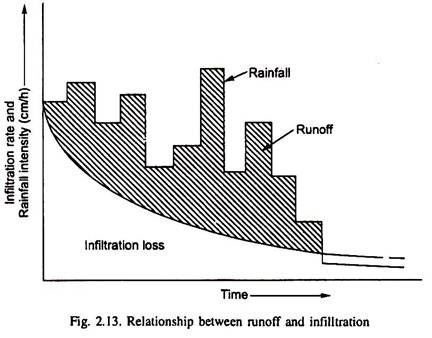
Infiltration may be defined as the entry of water from the top soil surface into lower soil profiles. The capacity of any soil to absorb the rain water, falling continuously at an excessive rate, goes on decreasing with time until infiltration is reached at the minimum rate i.e., at basic intake rate. The infiltration rate is the function of time.
The time based variation of infiltration rate is shown in figure 2.13. When infiltration curve is superimposed on the hyetograph (graph between rainfall intensity and time), then the area above infiltration curve indicates the excess rainfall, while area below the infiltration curve shows the loss of rainfall due to infiltration. This loss varies greatly in the early part of rainfall, which subsequently gets decease with increase in rainfall duration (Fig. 2.13).
Estimation of surface runoff volume from a large area having uniform infiltration characteristics, is done by subtracting the infiltration loss from the total rainfall. The amount of rainfall occurred on the watershed is determined by installing rain gauge, which records the rainfall depth.
If during a specific time of 6-h, there happens 15 mm rainfall over the watershed of 250 ha, then total volume of rainfall is equal to 250 × 104 × 0.015 m3 = 3.75 × 10⁴m3. And if average infiltration rate of watershed is 1.25 mm/h, then loss of rain water will be 1.25/1000 × 6 × 250 × 104 m3 = 18750m3. Thus runoff volume= 37500-18750 = 18750 m3.This method is known as infiltration indices method.
Infiltration Index:
Infiltration index is defined as the average rate of water loss through infiltration, such that the volume of rainfall excess is equal to the volume of direct runoff.
There are following two types of infiltration indices:
i. ɸ-Index:
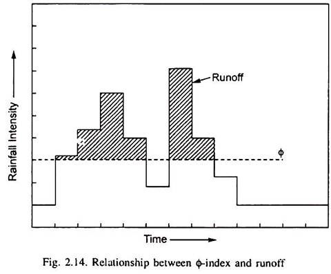
It is defined as the rate of rainfall, at which the volume of excess rainfall is being equal to the direct runoff volume (Fig. 2.14). The ɸ-index incorporates the initial loss of rain water, caused by infiltration phenomenon. It is predicted by counting as a constant rate of infiltration capacity.
The ɸ-index also demarcates the limit of rainfall intensity producing the runoff over the catchment, e.g., if rainfall intensity is less than the ɸ-index of the soil, then there is no runoff and when rainfall intensity exceeds the ɸ-index, then there resulted the runoff, which is equal to the difference between rainfall and infiltration during a specified time. The rainfall amount in excess of ɸ-index is referred as rainfall excess.
Numerically, the ɸ-index may be written as-
ɸ =Total basin recharge/Rainfall discharge
The above relationship is applicable, when rainfall intensity is continuously in excess of ɸ-index. This concept assumes that there is too much runoff is build up at the beginning of storm and too little at the end of storm due to the fact, that the peak rate of surface retention and infiltration rate decrease with time throughout the storm period. The ɸ-index is also known as retention rate rather than infiltration index.
ii. W-Index:
It is also known as average infiltration rate, is defined as the average rate of infiltration during the time, when rainfall intensity exceeds the infiltration capacity (i.e., maximum infiltration rate).
It is given by the following expression:
Where,
F = total water lost through infiltration
tr = time during which rainfall intensity exceeds the infiltration capacity
P = total amount of rainfall for the duration tr
Q = amount of surface runoff
S = amount of effective surface retention.
In the very wet condition, when infiltration rate of soil approaches to its basic intake rate and surface retention is at minimum level, then the values of W and ɸ-indexes are almost same. Under this condition W-index is known as Wmin – index.
B. Computation of Runoff by Empirical Formulae:
There have been developed several empirical formulae for computing the runoff for different zones of the country, few of them are described as under:
Runoff Coefficient Method:
In this method, the runoff is computed simply by multiplying the runoff coefficient to the rainfall amount, given as under:
R = K.P …. (2.35)
Where,
R = runoff, cm
K = runoff coefficient (dimensionless)
P = rainfall depth, cm
The values of runoff coefficient for different land uses are given in Table 2.7.
i. Inglis Formula:
Inglis (1940) developed following two empirical formulae for computing the runoff rate for two different types of area.
These are given as:
In above equations R is indicated for runoff depth (cm) and P is for rainfall depth (cm).
ii. Khosla’s Formula:
This formula was developed by Khosla (1953), assuming the temperature as a factor in yield of surface runoff.
The formula is given by:
in which, R and P are the same as in Inglis formula and T is the average temperature (°F) of the watershed.


