ADVERTISEMENTS:
In this article we will discuss about:- 1. Objective of Geosynclinal Orogen Theory 2. Base of the Geosynclinal Orogen Theory 3. Mechanism 4. Evaluation.
Objective of Geosynclinal Orogen Theory:
Famous German geologist Kober has presented a detailed and systematic description of the surface features of the earth in his book ‘Der Bau der Erde’. His main objective was to establish relationship between ancient rigid masses or tablelands and more mobile zones or geosynclines, which he called orogen.
Kober not only attempted to explain the origin of the mountains on the basis of his geosynclinal theory but he also attempted to elaborate the various aspects of mountain building e.g., formation of mountains, their geological history and evolution and development.
ADVERTISEMENTS:
He considered the old rigid masses as the foundation stones of the present continents. According to him present continents have grown out of rigid massess. He defined the process of mountain building or orogenesis as that process which links rigid masse with geosynclines. In other words, mountains are formed from the geosynclines due to the impacts of rigid masses.
Kober’s geosynclinal theory is based on the forces of contraction produced by the cooling of the earth. He believes in the contraction history of the earth. According to J.A. Steers (1932) “Kober is definitely a constructionist, contraction providing the motive force for the compressive stress”.
In other words, the force of contraction generated due to cooling of the earth causes horizontal movements of the rigid masses or forelands which squeeze, buckle and fold the sediments into mountain ranges.
Base of the Geosynclinal Orogen Theory:
According to Kober there were mobile zones of water in the places of present-day mountains. He called mobile zones of water as geosynclines or orogen (the place of mountain building). These mobile zones of geosynclines were surrounded by rigid masses which were termed by Kober as kratogen.
The old rigid masses included Canadian Shield, Baltic Shield or Russian Massif, Siberian Shield, Chinese Massif, Peninsular India, African Shield, Brazilian Mass, Australian and Antarctic rigid masses. According to Kober mid-Pacific geosyncline separated north and south forelands which were later on foundered to form Pacific Ocean.
ADVERTISEMENTS:
Eight morphotectonic units can be identified on the basis of the description of the surface features of the earth during Mesozoic era as presented by Kober e.g.:
(i) Africa together with some parts of Atlantic and Indian Oceans,
(ii) Indian Australian land mass,
ADVERTISEMENTS:
(iii) Eurasia,
(iv) North Pacific continents,
(v) South Pacific continents, and
(vi) South America and Antarctica etc.
Kober has identified 6 major periods of mountain building. Three mountain building periods, about which very little is known, are reported to have occurred during pre-Cambrian period. Palaeozoic era saw two major mountain building periods-the Caledonian orogenesis was completed by the end of Silurian period and the Variscan orogeny was culminated in Permo-Carboniferous period. The last (6th) orogenic activity known as Alpine orogeny was completed during Tertiary epoch.
Kober has opined that mountains are formed out of geosynclines. According to Kober geosynclines, the places of mountain formation (known as orogen) are long and wide water areas characterized by sedimentation and subsidence. According to J.A. Steers (1932) ‘Kober’s views (on geosynclines and orogenesis) are, then, a combination of the old geosynclinal hypothesis of Hall and Dana, which was developed later by Haug, and his own views on orogenesis.
Mechanism of the Geosynclinal Orogen Theory:
According to Kober the whole process of mountain building passes through three closely linked stages of lithogenesis, orogenesis and gliptogenesis. The first stage is related to the creation of geosynclines due to the force of contraction caused by cooling of the earth. This preparatory stage of mountain building is called lithogenesis. The geosynclines are long and wide mobile zones of water which are bordered by rigid masses, which have been named by Kober as forelands, or kratogen.
These upstanding land masses or forelands are subjected to continuous erosion by fluvial processes and eroded materials are deposited in the geosynclines. This process of sediment deposition is called sedimentation. The ever increasing weight of sediments due to gradual sedimentation exerts enormous pressure on the beds of geosynclines, with the result the beds of geosynclines are subjected to gradual subsidence.
This process is known as the process of subsidence. These twin processes of sedimentation and resultant subsidence result in the deposition of enormous volume of sediments and attainment of great thickness of sediments in the geosynclines.
ADVERTISEMENTS:
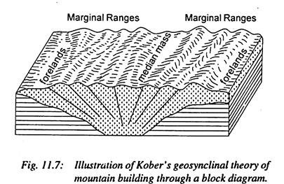
The second stage is related to mountain building and is called the stage of orogenesis. Both the forelands start to move towards each other because of horizontal movements caused by the force of contraction resulting from the cooling of the earth. The compressive forces generated by the movement of forelands together cause contraction, squeezing and ultimately folding of geosynclinal sediments to form mountain ranges. The parallel ranges formed on either side of the geosyncline have been termed by Kober as randketten (marginal ranges) (figs. 11.6 and 11.7).
According to Kober folding of entire sediments of the geosyncline or part thereof depends upon the intensity of compressive forces. If the compressive forces are normal and of the moderate intensity, only the marginal sediments of the geosyncline are folded to form two marginal randketten (marginal ranges) and middle portion of the glosyncline remains unaffected by folding activity (thus remains unfolded).
This unfolded middle portion is called zwischengebirge (be- twixt-mountains) or median mass (figs. 11.6 and 11.7).
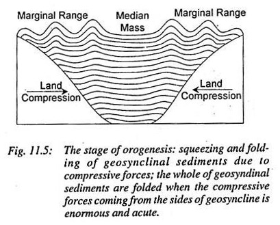
Alternatively, if the compressive forces are acute, the whole of geosynclinal sediments are compressed, squeezed, buckled and ultimately folded (fig. 11.5) and both the forelands are closeted. This process introduces complexity in the mountain because acute compression results in the formation of recumbent folds and nappes.
Kober has attempted to explain the forms and structures of folded mountains on the basis of his typical median mass. ‘Really, Kober’s typical “orogen” (geosynclines) well explains the origin of mountains’. ‘The idea of median mass of Kober fully explains the process of mountain building’. According to Kober the Alpine mountain chains of Europe can well be explained on the basis of median masses.
According to him Tethys geosyncline was bordered by European land mass in the north and by African rigid mass in the south. The sediments of Tethys geosycline were compressed and folded due to movements of European landmass (foreland) and African rigid mass (foreland) together in the form of Alpine mountain system. According to Kober the Alpine mountain chains were formed because of compressive forces coming from two sides (north and south).
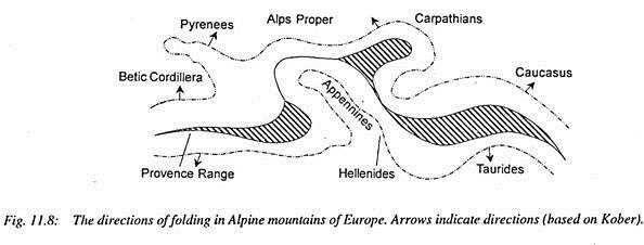
Betic Cordillera, Pyrenees, Provence ranges, Alps proper, Carpathians, Balkan mountains and Caucasus mountains were formed due to northward movement of African foreland (fig. 11.8). On the other hand, Atlas mountain (north-west Africa), Apennines, Dinarides, Hellenides and Taurides were formed due to southward movement of European land mass (fig. 11.8).
The median masses located in the Alpine mountain system very well explain the mechanism of mountain building. It is apparent from fig. 11.8 that the direction of folding in the Carpathians and Dinaric Alps (Dinarides) is north and south respectively, which means that Hungarian median mass is located between two mountain ranges having opposite directions of folding.
Mediterranean Sea is in fact an example of median mass between Pyrenees-Provence Ranges in the north and Atlas Mountains and their eastern extension in the south. Corsica and Sardinia are remnants of this median mass. Anatolian plateau between Pantic and Taurus ranges is another example of median mass. Similarly, further eastward, Iranian plateau is a median mass between Zagros and Elburz mountains.
Alpine mountains further extend into Asia where mountain ranges follow latitudinal direction e.g., west- east orientation but the latitudinal pattern is broken in north-eastern hill region of India where mountain ranges take southerly trend in the form of Burmese hills.
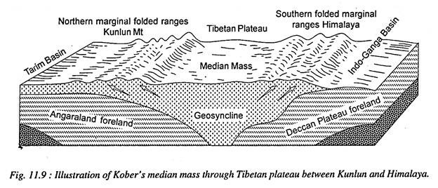
Asiatic Alpine ranges begin from Asia Minor and run up to Sunda Island in the East Indies. Kober has also explained the orientation of thrust or compression of Asiatic folded mountains on the basis of his foreland theory. Asiatic folded mountains including the Himalayas were formed due to compression and folding of sediments of Tethys geosyncline caused by the movement of Angaraland and Gondwana forelands together (fig. 11.9). Two marginal ranges (randketten) were formed on either side of the geosyncline and unfolded middle portion remained as median mass.
According to Kober Asiatic Alpine folded mountains can be grouped into two categories on the basis of orientation of folds:
(i) The ranges, which were formed by the northward compression, include Caucasus, Pantic and Taurus (of Turkey), Kunlun, Yannan and Annan ranges, and
(ii) The ranges, which were formed by the southward compression, include Zagros and Elburz of Iran, Oman ranges, Himalayas, Burmese ranges etc. Tibetan plateau is a fine example of median mass between Kunlun- Tien-Shan and the Himalayas.
The median mass may be of various forms e.g.:
(i) In the form of plateau (examples, Tibetan plateau between Kunlun and Himalaya. Iranian plateau between Zagros and Elburz, Anatolian plateau between Pantic and Taurus, Basin Range between Wasatch ranges and Sierra Navada in the USA);
(ii) In the form of plain (example, Hungarian plain between Carpathians and Dinaric Alps), and
(iii) In the form of seas (examples, Mediterranean Sea between African Atlas mountains and European Alpine mountains, Caribbean Sea between the mountain ranges of middle America and West Indies).
Third stage of mountain building is characterized by gradual rise of mountains and their denudation by fluvial and other processes. Continuous denudation results in gradual lowering of the height of mountains.
Evaluation of the Geosynclinal Orogen Theory:
Though Kober’s geosynclinal theory satisfactorily explains a few aspects of mountain building but the theory suffers from certain weaknesses and lacunae:
(1) The force of contraction, as envisaged by Kober, is not sufficient to cause mountain building. In fact, very extensive and gigantic mountains like the Alps, the Himalayas, the Rockies and the Andes cannot be formed by the force of contraction generated by cooling of the earth.
(2) According to Suess only one side of the geosyncline moves whereas the other side remains stable. The moving side has been termed by Suess as backland whereas stable side has been called foreland. According to Suess the Himalayas were formed due to southward movement of Angaraland.
The Gondwanaland remained stationary. This observation of Suess gained much favour previously but after the postulation of plate tectonic theory his views have become meaningless and the concept of Kober, that both the forelands move together, has been validated because ample evidences of palaeomagnetism and sea- floor spreading have shown that both Asiatic and Indian plates are moving towards each other.
(3) Kober’s theory somehow explains the west- east extending mountains but north-south extending mountains (Rockies and Andes) cannot be explained on the basis of this theory. Inspite of a few inherent limitations and weaknesses Kober is given credit for advancing the idea of the formation of mountains from geosynclinal sediments because geosyncline found berth in almost all the subsequent theories even in plate tectonic theory.


