ADVERTISEMENTS:
Here is a compilation of essays on ‘Winds’ for class 5, 6, 7, 8, 9 and 10. Find paragraphs, long and short essays on ‘Winds’ especially written for school students.
Essay on Winds
Essay Contents:
- Essay on the Introduction to Winds
- Essay on Prevailing Winds
- Essay on Wind Direction and Velocity
- Essay on the Measurement of Wind Direction and Speed
- Essay on the Types of Winds
- Essay on the General Circulation of the Wind
- Essay on the Effect of Wind on Crops
Essay # 1. Introduction to Winds:
Wind is air in horizontal motion in response to pressure gradient (rate of pressure changes with distance) or isobaric slope in atmosphere. Isobars are lines joining the places of equal pressure. Difference in temperature causes pressure change due to variation in density. As such, variation in temperature is the main cause of wind. Wind regulates the pressure inequalities on the earth surface. Pressure gradient is directly proportional to wind speed.
ADVERTISEMENTS:
The direction of wind is from the regions of high pressure to low pressure (high density to low density). It occurs in the direction of pressure decrease and takes place at right angles to isobars. The magnitude depends on the rate of pressure change (steepness of pressure gradient).
It is indicated by closeness of isobars. If the isobars are close, the gradient is steep and the velocity is high. If the isobars are far apart, the gradient is slow and the wind velocity is less. Two parameters are used for measuring wind—its direction and velocity.
Essay # 2. Prevailing Winds:
Winds are part of earth’s atmospheric circulation. In meteorology, prevailing winds are winds that blow predominantly from a single general direction over a particular point on earth’s surface. Dominant winds are the trend winds in the direction of wind with the highest speed over a particular point on earth’s surface.
A region’s prevailing and dominant winds are often affected by global patterns of movement in the earth’s atmosphere. In general, easterly winds exists at low and high latitudes globally. In the mid-latitudes, westerly winds are the rule and their strength is at the mercy of polar cyclone.
ADVERTISEMENTS:
In areas where winds tend to be light, sea breeze/land breeze cycle is most important to prevailing wind; in areas which have variable terrain, mountain and valley breezes dominate the wind pattern. Highly elevated surfaces can induce a thermal low, which then augments environmental wind flow.
Trades and their Impact:
Trade winds (also called trades) are the prevailing pattern of easterly surface winds found in tropics near earth’s equator, south of subtropical ridge. These winds blow predominantly from northeast in northern hemisphere and from southeast in southern hemisphere.
Trade winds act as steering flow for tropical cyclones that form over world’s oceans, guiding their path westward. Trade winds also steer African dust westward across Atlantic Ocean into Caribbean Sea, as well as portions of southeast North America.
Westerlies and their Impact:
ADVERTISEMENTS:
Westerlies or prevailing westerlies are the prevailing winds in middle latitudes between 35 and 65 degrees latitude, blow from west to east to north of high pressure area known as subtropical ridge in horse latitudes. These prevailing winds blow from west to east and steer extra-tropical cyclones in this general manner.
The winds are predominantly from southwest in northern hemisphere and from northwest in southern hemisphere. They are strongest in the wind when pressure is lower over poles, such as when polar cyclone is strongest and weakest during summer when polar cyclone is weakest and when pressures are higher over poles.
Together with the trade winds, westerlies enabled a round-trip trade route for sailing ships crossing Atlantic and Pacific oceans, as the westerlies lead to development of strong ocean
currents in both hemispheres. Westerlies can be particularly strong, especially in southern hemisphere, where there is less land in middle latitudes to cause the flow pattern to amplify, which slows the winds down.
Strongest westerly winds in middle latitudes are called roaring forties, between 40 and 50 degrees latitude, within southern hemisphere. Westerlies play an important role in carrying warm, equatorial waters and winds to western coasts of continents, especially in the southern hemisphere because of its vast oceanic expanse.
Polar Easterlies:
Polar easterlies (polar hadley cells) are the dry, cold prevailing winds that blow from high pressure areas of polar highs at north and south poles towards low pressure areas within the westerlies at high latitudes.
Unlike trade winds and westerlies, these prevailing winds blow from east to west and are often weak and irregular. Due to low sun angle, cold air builds up and subsides at pole creating surface high pressure areas, forcing an equator-ward outflow of air; that outflow is deflected eastward by Coriolis effect.
Local Considerations:
a. Sea and Land Breezes:
In areas where wind flow is light, sea breezes and land breezes (Fig. 2.6) are important factors in a location’s prevailing winds. Sea is warmed by sun to a greater depth than land due to its greater specific heat. Sea, therefore, has a greater capacity for absorbing heat than land.
Hence, the surface of sea warms up more slowly than land’s surface. As the temperature of surface of land rises, land heats air above it. Since warm air is less dense, it rises. This rising air over land lowers sea level pressure by about 0.2 per cent. Cooler air above sea, now with higher sea level pressure, flows towards land into lower pressure, creating a cooler breeze near the coast.
ADVERTISEMENTS:
Strength of sea breeze is directly proportional to temperature difference between land mass and sea. If an offshore wind of 8 knots (15 km hr-1) exists, sea breeze is not likely to develop. At night, land cools off more quickly than ocean due to differences in their specific neat values, which forces daytime sea breeze to dissipate.
If temperature onshore cools below temperature offshore, pressure over water will be lower than that of land, establishing a land breeze, as long as an onshore wind is not strong enough to oppose it.
b. Circulation in Elevated Regions:
Over elevated surfaces, heating of ground exceeds heating of surrounding air at the same altitude above sea level, creating an associated thermal low over the terrain and enhancing any thermal lows which would have otherwise existed and changing wind circulation of the region.
In areas where there is rugged topography that significantly interrupts environmental wind flow, wind circulation between mountains and valleys is most important contributor to prevailing winds. Hills and valleys substantially distort airflow by increasing friction between atmosphere and landmass by acting as a physical block to the flow, deflecting wind parallel to range just upstream of topography, which is known as a barrier jet.
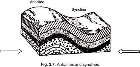
This barrier jet can increase low level wind by 45 per cent. In mountainous areas, local distortion of airflow is more severe. Jagged terrain combines to produce unpredictable flow patterns and turbulence, such as rotors. Strong updrafts, downdrafts and eddies develop as air flows over hills and down valleys (Fig. 2.7).
Wind direction changes due to contour of land. If there is a pass in mountain range, winds will rush through the pass with considerable speed due to Bernoulli principle that describes an inverse relationship between speed and pressure. Airflow can remain turbulent and erratic for some distance downwind into flatter countryside. These conditions are dangerous to ascending and descending airplanes.
Daytime heating and nighttime cooling of hilly slopes lead to day to night variations in airflow, similar to the relationship between sea breeze and land breeze. At night, sides of hills cool through radiation of heat. Air along the hills becomes cooler and denser, blowing down into valley, drawn by gravity.
This is known a katabatic wind or mountain breeze. If the slopes are covered with ice and snow, katabatic wind will blow during the day, carrying cold dense air into warmer, barren valleys. Slopes of hills not covered by snow will be warmed during the day. Air that comes in contact with warmed slopes becomes warmer and less dense and flows uphill. This is known as an anabatic wind or valley breeze.
c. Effect on Precipitation:
Orographic precipitation (Fig. 2.8) occurs on windward side of mountains and is caused by rising air motion of a large scale flow of moist air across mountain ridge, resulting in adiabatic cooling and condensation.
In mountainous parts of the world, subjected to consistent winds (for example, the trade winds), a more moist climate usually prevails on windward side of a mountain than on leeward or downwind side. Moisture is removed by orographic lift, leaving drier air on descending and generally warming, leeward side where a rain shadow is observed.
Essay # 3. Wind Direction and Velocity:
Wind direction is named by the direction from which it blows. If it is blowing from east to west it is eastern wind and the wind vane will point to east. If wind blows more frequently from one direction than from others, the direction is called prevailing wind direction. Wind direction can be indicated on a 16-32 point compass and is mentioned in terms of letter abbreviations of the directions by the number of compass point or by degree of north.
Wind turning to right from its course (clockwise direction) is called veering wind and that turning to left (anticlockwise) is called backing wind. Wind direction is reported in cardinal directions or azimuth degrees.
Wind direction is deflected from its normal course (pressure gradient) due to combined effects of:
1. Coriolis force.
2. Frictional force.
3. Centrifugal force.
4. Gravity.
The qualitative description of wind velocity and its effect on degree of shivering of plant parts/feathers or flag-like objects as given by Beaufort is given in Table 2.3:
At 3 m height, the frictional drag of earth is less. Wind velocity as measured at 3 m height indicate that the atmosphere remains calm mostly in the morning, the calmness being more from September to February. The wind velocities remain within the range of light air, slight breeze and gentle breeze, though sporadic cyclones do occur from October-November.
Essay # 4. Measurement of Wind Direction and Speed:
Air in motion, in response to pressure gradient in atmosphere, is called wind. Differences in temperature cause pressure change due to variation in density. As such, temperature variation is the main cause of wind. Direction of airflow is from the regions of high pressure to low pressure.
Wind Direction:
The direction of wind can be obtained with wind vane. It is essentially a broad arrow head mounted on ball-bearings to enable the arrow to move freely in the horizontal plane to indicate the direction of the wind. Below the movable system, there are eight fixed rigid bars, which are set to eight directions as shown in Fig. 2.9.
Wind vane is installed over a wooden plank fixed on a wooden post. The height between the pointer and ground level is 3.05 m (10 feet). The north indicator should be set to geographical north and not to the magnetic north.
There are two ways of indicating wind direction:
By Direction:
N, E, S, W, NE, SE, SW, NW, NNE, ENE, ESE, SSE, SSW, WSW, WNW and NNW.
By Degrees Clockwise from North:
N = 360°, E = 90°, S = 180°, W = 270°.
N, S, E, W—Cardinal directions
NE, SE, SW, NW—Sub-cardinal directions
NNE, ENE, ESE, SSE, SSW, WSW, WNW, NNW—Sub-sub-cardinal directions.
Wind Speed:
Wind speed is the speed of wind, movement of air or other gases in an atmosphere. It is a scalar quantity, the magnitude of vector of motion.
Wind speed has environment, but the speed of air movement inside is important in many areas, including weather forecasting, aircraft and maritime operations, building and civil engineering. High wind speeds can cause unpleasant side effects and strong winds often have special names, including gales, hurricanes and typhoons.
Anemometers are used for measuring the wind velocity. Robinson cup anemometer (cup anemometer) with four or three light aluminum cups fixed to arms of a steel cross mounted on vertical axis is commonly used in observatories (Fig. 2.5). Dine pressure tube anemometer is used in meteorological observatories.
The cups are set in motion due to pressure difference between convex and concave surfaces of the cups. The vertical spindle, about which the cups rotate, is connected to a mechanical counter called cyclometer through a gear system from which the number of rotations are counted and converted into speed calibrated in km hr-1.
The cup rotates in anti-clock direction. The range of cyclometer is from 0 to 999. The four black figures give whole km and the red figures to the right give tenths of km. The anemometer is installed on a metal pipe, which is fixed on a wooden post. The height from center of the anemometer cups is 10 feet (3.05 m) above ground level. Note down two readings from anemometer at an interval of three minutes.
Multiply the difference by 20 to get wind speed at the time of observation in km hr-1. The anemometer reading at 0700 hr LMT of the previous day should be subtracted from that at 0700 hr LMT of the observation day. Wind speed is measured in km hr-1 directly. In synoptic charts, wind speed is given in knots.
1 knot = 1 Nautical mile = 1.15 miles hr-1 = 1.85 km hr-1 = 0.52 m sec-1
1 mph = 0.8684 knots = 1.609 kmph = 0.447 m sec-1
1 m sec-1 = 1.94 knots = 3.6 kmph = 2.24 mph
Readymade tables are available for conversion of wind run into mean wind speed for 24 hours in km hr-1.
Factors Affecting Wind Speed:
Wind speed is affected by a number of factors and situations, operating on varying scales (from micro to macro scales). These include pressure gradient, Rossby waves and jet streams and local weather conditions. There are also links to be found between wind speed and wind direction, notably with the pressure gradient and surfaces over which air is found.
Pressure Gradient:
Is a term to describe the difference in air pressure between two points in the atmosphere or on the surface of the earth. It is vital to wind speed, because the greater the difference in pressure, the faster the wind flows (from the high to low pressure) to balance out the variation. Pressure gradient, when combined with Coriolis effect and friction, also influences wind direction.
Rossby waves are strong winds in upper troposphere. These operate on a global scale and move from west to east (hence being known as westerlies). Rossby waves are themselves a different wind speed from what we experience in lower troposphere.
Local weather conditions play a key role in influencing wind speed, as the formation of hurricanes, monsoons and cyclones as freak weather conditions can drastically affect the velocity of the wind.
Highest Wind Speed:
The highest surface wind speed ever officially recorded is 372 km hr-1 (231 mph) at the Mount Washington (New Hampshire) Observatory in US on 12 April 1934, using a heated wire anemometer.
The anemometer was later tested by US National Weather Bureau and confirmed to be accurate. The highest surface wind speed ever officially recorded in Asia was recorded in Afghanistan on 14 August 2008: 328 km hr-1 (204 mph) in Ab-Paran, Ghowr.
Wind-speeds within certain atmospheric phenomena (such as tornadoes) may greatly exceed these values but have never been accurately measured. The figure of 509 km hr-1 (316 mph) during the F5 tornado in Moore, Oklahoma is often quoted as the highest surface wind speed but was measured 30 m (90 feet) above ground.
Essay # 5. Types of Winds:
Depending upon the balance of forces involved, there are three major types of wind systems:
i. Gradient wind.
ii. Geostrophic wind.
iii. Thermal wind.
i. Gradient Wind:
In the upper atmosphere, where the surface friction is negligible, wind blow under the influence of pressure gradient force, gravitational force and Coriolis force. These winds are called gradient winds. Balance is not reached between pressure gradient force and Coriolis force.
Around lows, pressure gradient force exceeds Coriolis force and around highs Coriolis force exceeds pressure gradient force. The result is that in each case, there is a net inward directed force (centripetal force). When air flows in a curved path, Coriolis force balances the force due to pressure gradient and Coriolis force is called gradient wind.
ii. Geostrophic Wind:
When air flows in a straight line in the absence of frictional force, the only forces acting are the Coriolis force and the pressure gradient force. Wind blowing under these circumstances is called geostrophic wind.
The Coriolis force balances the pressure gradient force. This wind blows parallel to the isobars with high pressure towards right in the northern hemisphere. Above one km elevation from the surface, winds are geostrophic in nature.
iii. Thermal Wind:
The pressure changes slowly with height if the atmosphere is warm and rapidly if the atmosphere is cold. Thus, the thermal differences produce differences in wind velocity. Difference in temperature between the winds at the top and bottom of any layer is called thermal wind of the layer.
Essay # 6. General Circulation of the Wind:
Air constantly moves from place to place due to pressure differences caused by differences in temperature. Due to expansion of heated air, pressure decreases and air moves from high pressure to low pressure areas. It moves horizontally from high pressure areas to low pressure areas causing winds till it equalises the pressure of air.
General circulation (global circulation) is the genaralised wind system prevailing in the atmosphere due to differential heating of lower air by surface, which itself is heated by incoming solar radiation.
Net effect of differential heating of earth surface by insolation is to produce density and pressure differences that set the atmosphere in three dimensional motion. The role of general circulation is to convert solar energy into kinetic energy of the motion of air.
Predominant pressure belts that exist due to differential heating are:
a. Equatorial low or doldrums (0° latitude).
b. Subtropical high or horse latitude (30° N and S).
c. Sub-polar low (60° N and S).
d. Polar high (90° N and S).
These pressure systems exist in both the hemispheres. Due to N-S displacement of heating during the year, these pressure belts shift with season. The pressure belts cause permanent wind systems of general circulation. These wind systems are called global winds (Fig. 2.4).
Essay # 7. Effect of Wind on Crops:
Wind affects crops in several ways. The effects of wind, in general, are given in Table 2.3. At lower velocity, it has its soothing and beneficial effect and at higher velocity, it has its harmful and destructive effects. In general, plant growth appears to be inhibited by wind speed more than 10 km hr-1.
Winds cause maximum damage in association with rain at the time of flowering. Important effects of wind on crop production are:
1. Long exposure to strong winds causes morphological changes.
2. Strong winds develop xerophytic characters and increases root to shoot ratio.
3. Exposure of growing plants to hot wind results in dwarfing due to desiccation of plant tissue and reduced growth.
4. Wind increases crop water requirements by increasing evapotranspiration due to removal of accumulated humid air near the leaves.
5. Calm to moderate winds favour dew deposition needed under conditions of soil moisture stress.
6. Moderate wind aids in effective pollination. Heavy wind during flowering reduces pollination, causes flower shed, increases sterility and reduces fruit set in all crops.
7. Wind speed more than 50 km hr-1 leads to lodging of crops leading to heavy loss.
8. Leeward crops/plants yield more than those in windward.
9. Gluten content in wheat, protein content in pasture grasses and nicotine content in tobacco have been found to decrease due to protection of these crops from full wind exposure.
10. A minimum wind speed of 15 km hr-1 is needed for winnowing operations.
11. Wind stronger than 8 km hr-1 can lift sand in arid regions leading to formation of sand dunes.
12. In coastal areas, winds carrying salt sprays can have harmful effect on susceptible crops.
13. Soil and sand particles blown by wind strike the leaves and other plant parts making punctures, abrasions, lesions and tear the leaves in to pieces and strips. It will be well marked in maize, sugarcane and banana during summer.
It is known fact that papaya, banana, drumsticks and moringa do not survive in the villages adjacent to seashore due to continuous high wind velocity (>20 km hr-1) that makes these plants vulnerable to lodging, breaking up of tissues and uprooting. Due to deforestation, vulnerability of these areas to cyclone hazards has increased along Bay of Bengal coast.


