ADVERTISEMENTS:
Rainfall Essay – This is one of the best essays on ‘Rainfall in India’ especially written for school and college students.
Essay on Rainfall
Essay Contents:
- Essay on the Definition of Rainfall
- Essay on the Distribution of Rainfall
- Essay on the Characteristics of Rainfall
- Essay on the Variation of Rainfall
- Essay on the Measurement of Rainfall
- Essay on Factors Affecting Rainfall
- Essay on Rainfall Records and its Uses
- Essay on Average Rainfall in India
- Essay on the Dependability of Rainfall
- Essay on the Analysis of Rainfall Data
- Essay on Probable Extreme Rainfall Events
Essay # 1. Definition of Rainfall:
ADVERTISEMENTS:
Rainfall is a natural process in which atmospheric vapour changes into water. The water so formed then travels from atmosphere to earth. The term precipitation is also used for rainfall.
Rainfall occurs when the capacity of an air mass to hold the vapour exceeds because of the following reasons:
(1) Hot air has large capacity to hold the vapour particles in suspension. When air gets cooled the capacity of air mass to hold vapour particles is reduced and the vapour precipitates in the form of water.
(2) Sometimes variations in pressure bring about the change of state from vapour to rainfall.
The yearly, monthly or daily rainfall is expressed in centimetres or millimetres of depth over a particular area which receives the precipitation.
ADVERTISEMENTS:
Definition of One Centimetre Rainfall:
Suppose the water precipitated on a certain plain area in the form of a rainfall is not lost in any manner and if there is no runoff and evaporation whatsoever then all the water will go on accumulating on the surface of the area in the form of a layer. When the layer of this deposited water is one centimetre thick, it is said that one centimetre rainfall has occurred.
ADVERTISEMENTS:
ADVERTISEMENTS:
Essay # 2. Distribution of Rainfall:
Rainfall received during specified intervals like week, month or season indicate its distribution, which can be known by the rainy days, dry spells and wet spells. Distribution of rainfall in more important than total rainfall in a season for optimum crop yield. Yield levels depends on the amount of rainfall above the basic minimum required by the crop to achieve maturity. Yields, however, are not directly proportional to the rainfall.
On any particular day if the rainfall received is more than or equal to 2.5 mm, it is called a rainy day (meteorological rainy day). A day receiving more than 5 mm rainfall is called as crop rainy day. Number of rainy days indicates rainfall distribution in a season. Distribution is considered good if the rainfall is received in more number of rainy days.
All the intense rain received in a single occasion may not be entirely useful for crop. Part of it may be lost as surface runoff, deep percolation beyond root zone or by evaporation of rain intercepted by foliage. The extent of its utility in any given region determines effectiveness of rainfall or rainfall efficiency. Fraction of the total rainfall available for the consumptive use of crop is called effective precipitation (EP) or effective rainfall (ER).
Major factors influencing EP are:
1. Rainfall characteristics—amount, intensity and distribution of rainfall.
2. Land and soil characteristics—land topography, soil texture, structure, bulk density, permeability and infiltration.
3. Groundwater contribution.
4. Management factors—tillage, bunding, terracing, ridging, mulching etc., aimed at minimising surface runoff.
ADVERTISEMENTS:
5. Crop characters—root zone depth, degree of ground cover, growth stage etc.
Frequent light rains intercepted by foliage with full ground cover are close to 100 per cent effective. With large surface soil, rainfall upto 8 mm per day may be all lost by evaporation. Rainfall around 30 mm per day, with low ground cover, may be only 60 per cent effective.
To be reasonably safe from evaporation, the rain must penetrate to a depth of at least 10 to 12 cm. Rainfall needed for this purpose has been estimated at 15 to 20 mm for a single occasion. The annual effective rainfall commonly amounts to about one-third or 60 per cent of total rainfall.
Moving average of 10 years annual rainfall is calculated to know rainfall trend of a particular region. Around 50 years rainfall is necessary for this purpose. If rainfall data is available from 1965 to 1995, decennial averages from 1965 to 1974, 1966 to 1975, 1967 to 1976 etc., can be calculated and plotted in a graph from which the increasing and decreasing trend of rainfall can be determined.
Essay # 3. Characteristics of Rainfall:
Rain falling over a region is neither uniformly distributed nor is it constant over time. You might have experienced the sound of falling rain on a cloudy day approaching from distance. Gradually, the rain seems to surround you and after a good shower, it appears to recede. It is really difficult to predict when and how much of rain would fall. However it is possible to measure the amount of rain falling at any point and measurements from different point gives an idea of the rainfall pattern within an area.
In India, the rainfall is predominantly dictated by the monsoon climate. The monsoon in India arises from the reversal of the prevailing wind direction from Southwest to Northeast and results in three distinct seasons during the course of the year. The Southwest monsoon brings heavy rains over most of the country between June and October, and is referred to commonly as the ‘wet’ season.
Moisture laden winds sweep in from the Indian Ocean as low-pressure areas develop over the subcontinent and release their moisture in the form of heavy rainfall. Most of the annual rainfall in India comes at this time with the exception of in Tamil Nadu, which receives over half of its rain during the North East monsoon from October to November.
The retreating monsoon brings relatively cool and dry weather to most of India as drier air from the Asian interior flows over the subcontinent. From November until February, temperatures remain cool and precipitation low.
In northern India it can become quite cold, with snow occurring in the Himalayas as weak cyclonic storms from the west settle over the mountains. Between March and June, the temperature and humidity begin to rise steadily in anticipation of the South West monsoon.
This pre-monsoonal period is often seen as a third distinct season although the post-monsoon in October also presents unique characteristics in the form of slightly cooler temperatures and occasional light drizzling rain. These transitional periods are also associated with the arrival of cyclonic tropical storms that batter the coastal areas of India with high winds, intense rain and wave activity.
Rainfall and temperature vary greatly depending on season and geographic location. Further, the timing and intensity of the monsoon is highly unpredictable. This results in a vastly unequal and unpredictable distribution over time and space. In general, the Northern half of the subcontinent sees greater extremes in temperature and rainfall with the former decreasing towards the north and the latter towards the west.
Rainfall in the Thar Desert and areas of Rajasthan can be as low as 200 mm per year, whereas on the Shillong Plateau in the North-East, average annual rainfall can exceed 10,000 mm per year. The extreme Southern portion of the country sees less variation in temperature and rainfall. In Kerala, the total annual rainfall is of the order of 3,000 mm.
Essay # 4. Variation of Rainfall:
Rainfall measurement is commonly used to estimate the amount of water falling over the land surface, part of which infiltrates into the soil and part of which flows down to a stream or river.
For a scientific study of the hydrologic cycle, a correlation is sought, between the amount of water falling within a catchment, the portion of which that adds to the ground water and the part that appears as stream flow. Some of the water that has fallen would evaporate or be extracted from the ground by plants.
In Fig. 1.4 a catchment of a river is shown with four rain gauges A, B, C and D for which an assumed recorded value of rainfall depth have been shown in the Table 1.4.
It is on the basis of these discrete measurements of rainfall that an estimation of the average amount of rainfall that has probably fallen over a catchment has to be made.
Essay # 5. Measurement of Rainfall:
One can measure the rain falling at a place by placing a measuring cylinder graduated in a length scale, commonly in mm. In this way, we are not measuring the volume of water that is stored in the cylinder, but the ‘depth’ of rainfall. The cylinder can be of any diameter, and we would expect the same ‘depth’ even for large diameter cylinders provided the rain that is falling is uniformly distributed in space.
Now think of a cylinder with a diameter as large as a town, or a district or a catchment of a river. Naturally, the rain falling on the entire area at any time would not be the same and what one would get would be an ‘average depth’. Hence, to record the spatial variation of rain falling over an area, it is better to record the rain at a point using a standard sized measuring cylinder.
In practice, rain is mostly measured with the standard non-recording rain gauge the details of which are given in Bureau of Indian Standards code IS 4989 : 2002. The rainfall variation at a point with time is measured with a recording rain-gauge, the details of which may be found in IS 8389: 2003.
Modern technology has helped to develop Radars, which measures rainfall over an entire region. However, this method is rather costly compared to the conventional recording and non-recording rain gauges which can be monitored easily with cheap labour.
Essay # 6. Factors Affecting Rainfall:
Factors which affect the rainfall are the following:
(i) Nearness to Sea:
Coastal area receives more rainfall.
(ii) Presence of Mountain:
Mountainous region receives more rainfall than plain area.
(iii) Direction of Wind:
Movement of clouds depends upon the direction of wind. The area over which wind brings clouds will get rainfall.
(iv) Development of Forest:
The area with thick forest gets more rainfall.
(v) Height of a Place above Sea-Level:
At high altitudes temperature is low and hence when clouds reach that area they get cooled and precipitation takes place.
Essay # 7. Rainfall Records and its Uses:
Number of rain gauging stations in any basin depends on the extent of area, climatic and topographic conditions.
Numbers of gauging stations for various sizes of basins are given in Table 4.2. In plains, however, one rain gauge for every 500 sq. km. area is considered sufficient.
At each rain gauging station rainfall is measured after 24 hours. Usually the measurement is taken at 0830 hour I.S.T. Obviously total rainfall occurred in the past 24 hours is entered against the date on which measurement is done. The rainfall records are maintained on daily, monthly, seasonally or yearly basis for every rain gauging station. For satisfactory studies the length of record should be at least 30 years.
Uses of Rainfall Records:
The rainfall records are used for the following purposes:
(i) To study the trend of rainfall,
(ii) To calculate the run-off,
(iii) To predict the highest flood, and
(iv) To determine irrigation water requirement of crops.
Essay # 8. Average Rainfall in India:
On the Indian sub-continent rainfall is not equitably distributed. When one part of the country is flooded another part faces drought conditions. The yearly rainfall varies from about 125 mm in pockets of western Rajasthan to 10,000 mm in Cherapunji in Assam. Table 4.3 gives average yearly rainfall in parts of Indian states.
Determining Average Rainfall:
For determining the average rainfall in a particular catchment area, rain gauges are fixed at important point. The plan of the whole catchment area is prepared showing the position of the rain gauges. The area commanded or controlled by each rain gauge is marked on the plan. The average rainfall recorded by each rain gauge is marked in each area as shown in Fig. 2.5.
The common expression of rainfall is mm per year or mm/year. Fig, 2.5 shows the mean annual rainfall or precipitation for the various parts of the country. All the lines of equal rainfall or precipitation are known as isohyets and the map in which these lines are shown is known as isohyetal map.
The average rainfall over a catchment area is determined by Thiessen method, in which lines are drawn joining all the neighbouring observation stations or rain gauges sites. Now the perpendicular bisectors are drawn to these lines and the areas of the polygons thus formed around each station are measured. The area of each polygon so formed is multiplied with the average rainfall of that area.
The sum of the all the areas so obtained is divided by the total area to get the average rainfall in the whole catchment area.
Sometimes the average of all the rainfalls recorded by various rain gauges is determined, to get the average rainfall in the whole catchment area, but this is rough method and is not suitable for accurate calculation, for which Thiessen method is used.
The third method to determine the average rainfall in the catchment area is to be drawn isohyetal map of the area concerned and the mean rainfall in each isohyets area are determined. This is also accurate method.
Missing records extending over long periods, from one or more stations may be obtained by using the annual figures for the nearest stations multiplied by the ratio of the means of the two stations. For obtaining rainfall or precipitation during a storm the isohyets of the storm are drawn from the known figures, from which the missing data are determined by interpolation method.
The mean rainfall by Thiessen’s mean method is determined by the following formula:
P = A1P1 + A2P2 + A3P3 + …….. + AnPn/A
Where P = Mean rainfall on the basin
A = Basin area.
P1, P2, P3…Pn represent rainfalls at the respective sations whose surrounding polygons have the areas A1, A2, A3,… An respectively.
Essay # 9. Dependability of Rainfall:
Expected rainfall at certain level of probability (chance) will be more dependable than arithmetic averages. There are two types of probabilities: initial and conditional probability. Initial probability indicates the quantity of rainfall at a particular probability (50 or 75%) during a month or a week in a locality.
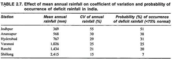
Conditional probability indicates the level at which a particular amount of rainfall is anticipated in a particular place over a specified period, normally in a week. As a rule, CV is more in areas with low rainfall (Table 2.7).
Essay # 10. Analysis of Rainfall Data:
Study of rainfall over a long period is, usually, referred to as rainfall climatology.
It gives information on general pattern and characteristics of rainfall of a particular place or a region that helps in:
1. Understanding rainfall characteristics (amount, intensity and distribution) of a place.
2. Selecting efficient cropping systems.
3. Taking decisions on timing of agricultural operations like optimum time for sowing, inter-cultivation, fertiliser application, scheduling irrigation, plant protection, harvesting, etc. for different crops.
4. Grouping places or regions with similar rainfall characteristics (classification of climate) for adoption of package of production practices for different crops.
Total rainfall or its mean over certain period is of little use in crop production. Rainfall of a place can be meaningfully described if its intensity, duration and frequency are known. Rainfall intensity is the rate at which rain falls; duration of rainfall is the time for which rain is falling with that intensity and frequency of rainfall is the number of times it falls. Other rainfall characteristics of importance in crop production are rainfall probability, variability and dependability.
To sum up, the following rainfall characteristics have significant influence on crop production:
1. Rainfall probability, variability and dependability.
2. Intensity, duration and frequency of rainfall.
3. Rainy days.
4. Effective precipitation.
The WMO has divided calendar year into 12 durations of 30 days each—called periods and 52 weeks—called standard meteorological weeks of 7 days each. The first week starts on 1st January and ends on 7th January and so on. The 9th (26th Feb to 4th March) week in a leap year and the 52nd week consist of 8 days.
Mean Rainfall:
The amount of rainfall collected by a given rain gauge in 24 hours is known as daily mean rainfall (mm or cm) and the amount collected in one year in known as annual rainfall. The mean of the annual rainfalls over a period of 35 years (in India) is known as mean annual rainfall (average annual rainfall or normal annual rainfall).
In any particular year, the rain may not be equal to annual mean. It may be less or more than the annual mean value. The ratio of the actual rainfall in a particular year at a given place to the normal annual rainfall at that place is known as index of wetness.
Index of wetness, thus, gives an idea of wetness of an year, indicating the deficiency of rainfall. A 60 per cent index of wetness means a rainfall deficiency of 40 per cent. A deficiency of 30 to 45 per cent is known as large deficiency, 30 to 45 per cent as serious deficiency and more than 60 per cent as disastrous deficiency.
Coefficient of Variation:
Assessment of rainfall variability through coefficient of variation (CV %) appears to be simple.
The CV can be obtained by dividing standard deviation by mean rainfall as indicated below:
The greater the CV, the lesser the dependability of receiving rainfall. Considering the annual CV, the IMD is using the following criteria for assessing the rainfall variability in a particular area.
Normal = -19 to 19 per cent of annual normal rainfall
Deficit = -20 to -59 per cent of annual normal rainfall
Scarce = -60 per cent and above of annual normal rainfall.
Essay # 11. Probable Extreme Rainfall Events:
Two values of extreme rainfall events are important from the point of view of water resources engineering.
These are:
i. Probable Maximum Precipitation (PMP):
This is the amount of rainfall over a region which cannot be exceeded over at that place. The PMP is obtained by studying all the storms that have occurred over the region and maximizing them for the most critical atmospheric conditions. The PMP will of course vary over the Earth’s surface according to the local climatic factors.
Naturally, it would be expected to be much higher in the hot humid equatorial regions than in the colder regions of the mid-latitudes when the atmospheric is not able to hold as much moisture. PMP also varies within India, between the extremes of the dry deserts of Rajasthan to the ever humid regions of South Meghalaya plateau.
Methods of Estimating PMP:
Probable maximum precipitation for a river basin may be estimated by using storm models or storm transposition and maximization.
(a) Storm Models:
Precipitation rates are a function of the availability of atmospheric moisture and the rate at which this moisture can be converted into precipitation. Attempts have been made to develop storm models for the theoretical derivation of probable maximum precipitation.
A major difficulty in such studies has been to account for orographic effects on precipitation intensities. The difficulty arises because, within a particular storm, variations in precipitation are related both to changes in the storm mechanism and to orography.
In order to determine probable maximum precipitation by means of a storm model, upper-limits of moisture and wind for various levels throughout a layer of the atmosphere, the depth of which is a function of the model characteristics are estimated and processed through the model. In many regions, the shortness of record and/or sparsity of upper-atmosphere wind and humidity observations complicates the estimation of upper-limit values.
(b) Storm Maximization and Transposition:
A more commonly used approach to the estimation of probable maximum precipitation involves the maximization of observed storm-precipitation data.
Storm maximization is usually based on two assumptions:
(i) Precipitation can be expressed as the product of the available moisture and the combined effect of the storm efficiency and the inflow of wind; and
(ii) The most effective combination of storm efficiency and inflow wind can be estimated from outstanding storms on record. This second assumption often necessitates storm transposition, that is, the relocation of an outstanding storm from the area of its occurrence to a project basin within the same region of meteorological homogeneity.
The maximization of observed storm precipitation for determining probable maximum precipitation involves moisture adjustment with the basic assumption that a storm would have produced maximum precipitation had the maximum moisture supply been available.
The method of moisture adjustment commonly used involves the estimation of air-mass moisture content, taken as the precipitable water, from surface level dew-point observations and has been described in the WMO Manual for Estimation of Probable Maximum Precipitation.
In order to carry the maximum moisture supply into the project basin further adjustment of storm-precipitation data to the estimated maximum sustained wind is made by some investigators if very high design-safety factors are desired or if only a limited amount of storm-precipitation data are available.
ii. Preliminary Estimates:
For major structures, the cost of the spillway may be an appreciable portion of the total cost of the project. Proper design of dimensions is important enough to warranta very detailed study. However, in preliminary planning stages, it is sufficient to use generalized estimates of probable maximum precipitation if these are available for the area. Estimates of this type have been prepared by many countries for various parts of the world.


