ADVERTISEMENTS:
Here is a compilation of essays on ‘Earth’ for class 7, 8, 9, 10, 11 and 12. Find paragraphs, long and short essays on ‘Earth’ especially written for school and college students.
Essay on Earth
Essay Contents:
- Essay on the Origin of the Earth
- Essay on the Composition of the Earth
- Essay on the Motions of the Earth
- Essay on the Movement of the Earth
- Essay on the Interior of the Earth
- Essay on the Theories of the Earth
- Essay on the Numerical Facts about the Earth
- Essay on the Energy Intercepted by the Earth
Essay # 1. Origin of the Earth:
ADVERTISEMENTS:
The earth came into existence between 5000 to 6000 million years ago from condensed form of a cloud of gases. By studying the hot, luminous gases of the sun, we find that sun is made of the same basic elements that are found by chemical analysis of earth’s material. In fact all the stars which have been studied seem to have the same elements.
Origin of Continents and Basins:
At present the crust of the earth is largely made up of two different kinds of materials of rocks called granite and basalt. The average specific gravity of the earth is 5.5 while that of granite and basalt is 2.7 and 3.0, respectively. Granite is typically found in continental areas and the ocean floors are made of basalt.
If rafts of basalt and granite could be imagined as floating on a very heavy plastic material, the elevation of continents could be imagined as being due to the lower specific gravity of granite in the continents and the greater specific gravity in the basins.
We do not know just how the surface of the crust became separate into granite and basaltic sectors. One theory is that while the earth was still liquid, masses of granite, like flocks of foam, floated in a still liquid basaltic sea.
ADVERTISEMENTS:
When the crust was solidified, the granite masses projected to form the continents. Another hypothesis holds that the continents have been growing throughout earth’s history by building of successive thick mountain ranges.
Essay # 2. Composition of the Earth:
The outer envelopes of the gaseous material surrounding the earth are called atmosphere. Under the atmosphere is our earth on which we live. That part of the earth, which is in the form of a land, is known as the earth’s crust. It also includes the highest peaks of mountains and floors of the oceans. Part of the land, which is visible on the Globe, is called the Lithosphere (Greek, Litho = Stone).
ADVERTISEMENTS:
We know that nearly 75 per cent of the whole surface of the earth is covered with natural waters like oceans, seas, lakes, rivers etc. Which is in the form of more or less, a continuous envelope around the earth.
This envelope of water is called Hydrosphere (Greek, Hudous = Water). Thus, Lithosphere and Hydrosphere in a combined form is known as the Earth’s crust. Under the Earth’s crust is the interior of the Earth. It is further sub-divided into three shells. Depending upon the nature, the material is made up as shown in the Fig. 1.1.
The earth is composed of different rocks. In an ordinary sense the term rock means something hard and resistant but the meaning of the word has been extended so as to include all natural substances of the Earth’s crust, which may be hard like granite or soft like clay and sand.
It has been estimated that 95 per cent of the Earth’s crust is made up of primary i.e., first formed (Igneous) rocks which is mostly composed of Granite having Quartz, Feldspar, Biotite mica and Hornblende in varying proportions the remaining 5 per cent of the crust is made up of Secondary (Sedimentary or Metamorphic) rocks (as shown in Fig. 1.2). The Earth’s crust is in the form of a very thin layer of solidified rocks and is heterogeneous in nature.
These rocks may be classified on the basis of their density into the following two groups:
1. Sial (Si = Silicon and A1 = Aluminium) having density 2.75 to 2.90.
ADVERTISEMENTS:
2. Sima (Si = Silicon and Ma= Magnesium) having density 2.90 to 4.75.
It has been estimated that the Sial rocks are about 70 per cent of the Earth’s crust, which include chiefly Granite and Silica. These rocks are generally on the upper regions of the crust.
Sima rocks include heavy and dark coloured rocks like Basalts. In these rocks, the percentage of Silica is reduced and Magnesium attains the next importance in place of Aluminium of Sial rocks. These rocks are generally found on the floors of the Oceans and beneath Sial rocks.
Mantle:
It is the part of the earth below the crust and surrounding the core. The imaginary line that separates the lithosphere from the mantle is known as ‘Moho’ (Mohorovicic discontinuity). Because of high temperature and great pressure, the mineral matter in this part is the molten condition.
Core:
It is the innermost layer of the earth; it extends from below the mantle (Gutenberg discontinuity) to the central part of the earth.
On the basis of earthquake waves, the core has been further divided into two cores:
(a) Outer core.
(b) Inner core.
The outer core is 2,250 km thick and surrounds the core. It is believed that it is still in molten condition.
The inner core is also called ‘Nife’ because it consists of Nickel and iron. Its thickness is about 1,228 km. It is very hard in nature.
Essay # 3. Motions of the Earth:
The earth is held in space by combined gravitational attraction of sun and other heavenly bodies and has motions that are controlled by them.
The two principal motions of earth are:
1. Rotation of earth about its axis
2. Revolution of earth around sun
(i) Rotation:
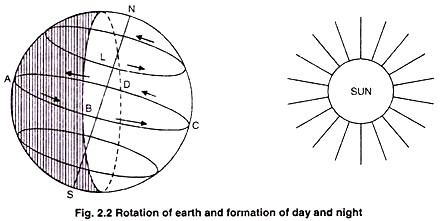
The earth rotates upon an imaginary axis, which owing to the polar flattening is the shortest diameter. The earth rotates from west to east (in anti-clockwise direction) and it takes 24 hours to complete one rotation. During this period most of the places on the sphere are turned alternately towards and away from the sun, have experienced a period of light and darkness.
This causes day and night. This unit of time is called solar day. The direction of rotation (west to east) not only determines the direction in which the sun and stars rise but is also responsible for the direction of prevailing winds and ocean currents.
Importance of earth’s rotation:
The effects of the earth’s rotation are of great importance to the environment. The rotation indirectly accounts for the diurnal changes in weather such as warming up during daytime and cooling down at night. Thus the rotation affects diurnal rhythm, day light, air temperature, air humidity and air motion. Plants and animals respond to this diurnal rhythm. Green plants store energy during day and consume some part of heat during night.
Rotation of earth turns both air and water in one direction. The flow of air and water are turned towards right in the northern hemisphere towards left in the southern hemisphere. This phenomenon is called the coriolis effect. It is of great importance in studying the earth’s systems of winds and ocean currents.
(ii) Revolution:
The path of the earth around the sun is called orbit and the rotating earth revolves in a slightly elliptical orbit about the sun from which it keeps an average distance of 150 million km.
The time required for the earth to pass one complete orbit fixes the length of the year and this journey takes a few minutes less than 3651/4 days (365.242 solar days). Earth revolves around the sun in anticlockwise direction. The rate of earth’s revolution is more than 1,06,260 km/hour.
Importance of revolution:
The rotation and revolution of earth are of great significance in meteorology. The rotation indirectly accounts for the diurnal changes in weather such as warming up during daytime and cooling down at night. Seasonal changes are dependent on the revolution of earth. When the earth is at perihelion (January 3), the sun is close to the earth, as a result greater intensity of solar radiation is received at the earth surface.
This position occurs during winter season. When the earth is at aphelion, the earth is farthest from sun, as a result the heat received at the earth surface is less. This occurs during summer season (July 4). However, the distance between sun and earth varies only about 3 per cent during one revolution.
As the earth moves forward in its orbit, its axis remains inclined at 231/2° from the perpendicular to the plane of the earth’s orbit. This tilt of 231/2° does not change throughout the year as the earth revolves around the sun.
It causes the change in seasons regularly through spring, summer, autumn and winter because of the inclination of the earth’s axis, constant direction of tilt of that axis and revolution of the earth around the sun.
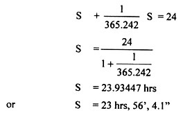
Sidereal day:
The true rotation time is called sidereal day. It is denoted by ‘S’.
The number of hours, minutes and seconds in a sidereal day are given below:
Lengths of the day:
Earth receives solar radiation from the sun during day time. Day length can be defined as the total time between sunrise and sunset. Length of the day is partly controlled by the latitude of the earth and partly by the season of the year. The day length at the equator is about. 12 hours throughout the year, whereas at the poles it varies between 0 and 21 hours from winter to summer.
Solar radiation received at any location of the earth depends upon the day length. Maximum amount of solar radiation is received in the higher latitude during summer solstice because it is period of continuous day.
The amount of solar radiation received during the December solstice in southern hemisphere is theoretically greater than that received in the northern hemisphere during the June solstice. The equator has two radiation maxima at the equinoxes and two minima at the solstices.
Length of the day plays an important role in the life cycle of the crop plants. In fact, day length indicates the photoperiod available for the growth of the crop plants. Every plant requires different photoperiod for the initiation of flowering. On the basis of day length, plants can be divided into different categories. The plants which require less than 10 hours day length, are called short day plants.
If the requirement of the plants is greater than 14 hours day length, then these are called long day plants. In between these two types, there are intermediate plants, which require photoperiod of 12 – 14 hours. However, the plants which are not affected by day length, are called day neutral plants.
Essay # 4. Movement of the Earth:
Many changes on the crust of the earth can be seen as a result of the works of internal forces in the earth’s interior. The works of internal forces are generally called earth movement. Sometimes, the earth movement may be very very slow and sometimes it may be sudden.
It is believed that originally the landmasses were united together in the form of a great landmass known as Pangaea. In course of time the Pangaea had broken into several pieces and drifted into different directions. The drifting is called Continental Drift and the theory was propounded by Alfred Wagner. The northern part of the landmass was known as Laurasia.
Eventually it had broken down to form North America, Europe and Asia. About 120 million years ago, the southern part of India, East Africa, Madagascar, Australia, South Africa, South America and the Antarctica were together and formed the single landmass known as ‘Gondwana land’. The ‘Gondwana land’ started breaking into several pieces and India took its present shape about 60 million years ago.
During the last million years, the Himalayas had risen to its present height due to earth movements. Similarly, it has been proved that the Aravallies and the Vindhyas in the middle of India were once at the bottom of the sea.
The forested areas near Bombay harbour, the Mahabalipuram temple in the sea, submergence of a vast area of nearly 5000 sq km in the Runn of Kutch during 1819 and a land of about 1500 sq km raised to a height of several metres, are some of the results of the earth movement.
The earth movements which bring about vast changes are called Tectonic movements. It has been already mentioned that earth movements may be very slow and sudden.
Slow Movements:
The slow movements of the earth’s crust are due to various chemical and physical reactions that take place at the earth’s interior. The movement may be so slow that its result may not be seen on the surface during 100 to 200 years.
The raising of the eastern coastal plain up to a height of 15-30 metres, the existence of coal beds below the sea level in the Sundarban Delta, the existence of a forest near the Bombay harbour and submergence of a vast area in the Runn of Kutch are some of the Indian examples of slow earth movement.
A change in sea level in its advance or retreat with respect to adjacent land is relative to each other. When the sea advances to land, it is generally called a Positive Movement and the land advancing against the sea is known as Negative Movement.
On the basis of the structural changes that are caused by the tectonic movement, the earth movements may be grouped into two classes:
(i) Vertical or Epeirogenic Movement
(ii) Horizontal or Orogenic Movement.
Vertical Movement:
Due to earth movement some parts of earth surface may be raised or sunk with respect to the surrounding areas. This type of movement is known as Vertical Movement. When a part of the earth’s crust is raised in relation to its surrounding area, it is known as uplift. In the same way when a portion is sunk in relation to its surrounding areas, it is called subsidence.
Earth movement of this type, when takes place over extensive area generally leads to the building up of continents and Plateaus. That is why, this type of movement is also known as Epeirogenic movement or Continent building movement. As a result of their movement, the horizontal arrangement of the earth’s crust remains almost undisturbed.
Millions of years ago there used to be a continent where we find Atlantic Ocean today. In the beginning of the earth’s history such movements had been more frequent and the present-day arrangement of the continents might have been the result of this movement.
Horizontal Movement:
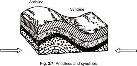
The forces of horizontal movement affect tangentially. It involves both the forces of compression and tension. These two types of movements are related to each other. Compression in one part of the crust is bound to produce tension at another place. The compression leads to the bending of horizontal layers into a shape known as fold.
The tension is responsible for breaking of rock layers with subsequent sliding or displacement. It is known as fault. The processes of making folds and faults are known as folding and faulting.
When two horizontal forces act towards a common point from opposite directions folding takes place. Deep within the earth, this force tends to cause bending of rock strata. Like seawaves, rocks are thrown into upfolds and downfolds. The upfolds are called anticlines and the downfolds are known as synclines.
When two forces act horizontally in opposite directions from a common point, it generates tension and the process is known as faulting. As a result, the rocks break along a line which is known as fault line. The faulted rocks may be thrown upwards or slided downwards.
The mountains over the surface of the earth owe their origin to the process of folding and faulting. That is why, the horizontal movement is also known as orogenic or mountain building movement. The Himalayas on the northern border of India, the Alps of Europe, the Rockies of the North America and the Andes of South America are some of the newly folded mountain ranges of the world.
Aravallies, Ural, Tiensan and Appalachia are some of the old folded mountains of the world. Similarly, the Black Forest of Germany, the Voges of France, the Vindhyas and the Satpura of India are some of the examples of fault or block mountains of the world.
Plate Tectonics:
Plate tectonics is the most modern theory about the formation of folded mountains. According to this theory, the world has been divided into six major plates and several smaller plates. Each of the plates is composed of crust up to a depth of 100 km from the surface of the earth.
Due to the forces at the earth’s interior, these plates are moving in different directions. As a result of rubbing of the two plates, the folded mountains have been formed at the edges of the plates.
The six major plates are:
(1) Pacific Plate
(2) North American Plate
(3) South American Plate
(4) African Plate
(5) Eurasian Plate
(6) Indo-Australian Plate.
The smaller plates are:
(a) China Plate
(d) Nazca Plate
(c) Cocos Plate
(b) Antarctic Plate
(e) Caribbean Plate
Where plates separate and new ocean floor is created, mid-ocean ridges are the boundaries. The plates are rigid. Their boundaries are marked by earthquakes and often by volcanoes. Where plates collide and overlap, young mountains, arcs and trenches are the boundaries.
Sudden Movement:
Sudden movement of the earth crust can be noticed during earthquake. Some parts of the land surface of New Zealand were raised by about 3 metres during the earthquake of 1885. Similarly, some areas of Japan sank by about 6 metres during 1891 earthquake. Recently, during the earthquake of 1950, the bed of the Brahmaputra River had been raised leading to various changes in the valley.
Essay # 5. Interior of the Earth:
To know exactly about the interior of the earth is more difficult than that of taking photograph of other planets with the help of satellites or by walking on the surface of the moon. It has not been possible till today to collect direct evidences about the structure of the earth.
However, geographers and geologists have collected indirect evidences about the structures and composition. On the average, the radius from the centre to the surface of the earth is 6320 km but, the deepest mine in the world in South Africa is about only 4 km deep and man could dig up to a maximum depth of 6 km in search of oil.
In other words, man has been able to get direct evidences about the structure and composition of the earth’s interior up-to a depth not more than 5 to 6 km from the surface.
The knowledge beyond this limit is based primarily on indirect scientific evidences. The indirect evidences are based on temperature and pressure inside the earth, density of materials and behaviour of earthquake waves. Still uncertainty persists. On the basis of the different scientific observations it has been concluded that there exists different layers inside the earth.
Temperature and Pressure of the Earth’s Interior:
The hot and molten lava, ash, smoke that come out at the time of volcanic eruption as well as the hot water springs are some of the evidences which confirm that interior of the earth is having a very high temperature. It has been found from mining operations also that the temperature increases at the average rate of 1°C per 32 metres depth.
At this rate of increase of temperature, the rocks at great depth of the earth’s interior should be in molten state. Actually, this was the view earlier that the crust of the earth is floating on a massive molten materials.
But, the study of earthquake waves has indicated that the temperature does not increase uniformly from the surface to the centre of the earth. The rate of increase in temperature is not uniform. Scientists also have proved that the main reasons of increase in temperature are the fusion of radio-active materials and other chemical reactions. The tremendous pressure from the overlaying materials makes the melting point higher.
On the basis of this, in upper 100 km, increase of temperature is estimated to be 12°C per km; in the next 300 km it is 2°C per km and below it 1°C per km. At this rate the temperature at the core of the earth is estimated to be 6000°C.
At this temperature, the materials in the central part of the earth’s interior should have been at gaseous state but due to tremendous pressure from the outer layers, the materials assume liquid properties and acquire properties of solid or plastic state. Therefore, the earth behaves mostly as solid down to a depth of 2900 km because of tremendous pressure.
Density and Composition of the Earth’s Interior:
By studying the speed and path of earthquake waves, temperature and pressure conditions inside the earth, scientists are of the opinion that the physical properties, density and composition of the materials are different at varying depths. The structure of the earth is therefore layered. The earth consists of three layers, one inside the other like an onion. They are the crust, the mantle and the core.
The topmost layer of the earth is solid, the thinnest, and the lightest and is known as Lithosphere. The lithosphere has again two layers-outer part immediately below the newer sedimentary formation, popularly known as crust and the inner part of greater strength. The crust of the earth is composed of sedimentary and granitic rocks.
The inner layer of lithosphere has basaltic and ultra-basic rocks. While the outer layer of lithosphere is found mainly under continents, the inner layer is found partly under oceans. The average density of lithosphere is 2.65 to 2.90. ‘Silica’ and ‘Aluminium’ are abundant. Therefore, it is popularly known as SIAL (Silica + Aluminium). The average thickness is 8 to 100 km.
Below this top layer is the layer of basalt rock which is heavier than the topmost layer. The density varies from 3.1 to 5.00. It assumes the properties of solid and partly plastic materials. The average thickness of this layer is 100 to 2900 km. In this layer, Silica and Magnesium elements predominate and it is popularly known as SIMA (Silica + Magnesium).
The SIMA also has two layers—Inner silicate layer at the top with average thickness of 100 to 1700 km and Transitional zone of mixed metals and silicates with an average thickness of 1700 to 2900 km. These two SIMA layers are also known as MANTLE. The surface that separates crust and mantle is known as Mohorovicic Discontinuity or simply MOHO.
Finally, the innermost layer exists at the central core of the earth with density 5.1 to 13.00. It is composed of the heaviest mineral materials. This central mass is mainly made of ‘nickel’ and ‘iron’ therefore known as NIFE (Nickel + Ferrous). The core contains 1/3 of the entire mass of the earth.
The materials of this part may be in liquid, plastic or even solid state due to tremendous pressure from above. It has also two layers-outer metallic core with average thickness of 2900 to 4980 km and inner metallic core between 4980 to 6400 km. The inner metallic core is also known as Barysphere (Fig. 2.4).
The three layers of the earth have been called by different geologists in different manners. German scientist Gracht called them SIAL, SIMA and NIFE. Jeffrey called them as Top, Middle and Lower layers while Professor Holmes called them the Crust, the Substratum and the Core. The relationship has been mentioned in Table 2.2.
From Table 2.2, it can be estimated that crust of the earth forms less than 1 per cent; mantle 16 per cent and 83 per cent makes the core. The earth being a spherical body has materials of varying densities at varying depths.
Materials of the Earth’s Crust:
The word ‘Lithosphere’ means a sphere of rocks. The upper portion of lithosphere is referred to as the crust of the earth. Down to depth of nearly 16 km from the surface under the continents, 95 per cent of the materials that form the crust consist of rocks and the rest 5 per cent minerals.
The term rock refers to hard masses of earth’s crust as well as loose and soft particles like sand and clay. The rocks are formed of the mixture of various minerals. All rocks do not have same chemical composition and structure.
But, every mineral has its own chemical composition and physical properties. The minerals generally occur in the form of crystals. The rocks and minerals are generally composed of certain chemical elements like oxygen, silica, aluminium, iron and calcium, etc.
Minerals:
Each mineral usually contains two or more simple substances called elements. There are about 2000 minerals but only 12 are common all over the earth. These 12 minerals are basically responsible for the formation of rocks.
Mineral may be defined as a naturally occurring non-living solid substance possessing certain physical properties and definite chemical composition. The minerals may be either elements or compounds and also metallic or non-metallic.
The most abundant elements in nature are silicates, carbonates, chlorides, sulphates and oxides. As much as 87 per cent of the minerals of the earth’s crust are silicates and 59 per cent of the rocks are formed of the minerals of silica group.
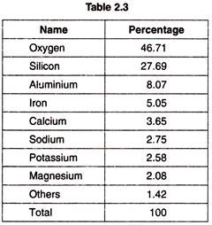
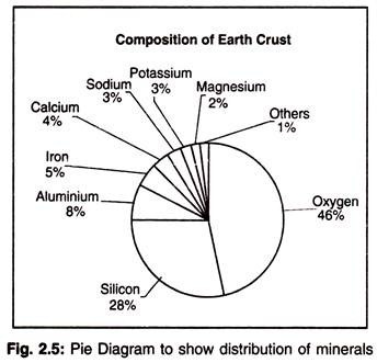
The distribution of minerals in the earth’s crust is as follows (Table 2.3):
Minerals are of two types-Rock forming and Ore forming:
Quartz:
It is one of the most abundantly available minerals in earth’s crust. It has two elements— Silicon and Oxygen. They unite together to form a compound, known as carbonate of lime. It is transparent in its pure state. However, quartz may be of different colours when it is mixed up with other elements. Its hardness is 7, specific gravity 2.65. Quartz is hexagonal and its structure is SiO2 (Silicon dioxide).
Feldspar:
Feldspar is one of the important elements of rock and nearly 50 per cent of the earth’s crust is composed of feldspar. It is made of silicates of aluminium, potassium, sodium, calcium and oxygen. Feldspar is of two types—Orthoclase and Plagioclase.
Orthoclase has specific gravity of 2.57, its hardness is 6 and structure is Ca2SiO4 (Calcium Silicate). The specific gravity of plagioclase feldspar is 2.60 to 2.74, hardness is 6 to 6.5 and the structural formula is Na2OAl2O6SiO2 (Sodium Aluminium Silicate) and CaOAl2O32SiO2 (Calcium Aluminium Silicate).
Mica:
Mica is formed of the elements of hydrogen, potassium, aluminium, magnesium, iron and silicon. Mica is of two types—Black Biotite and White Muscovite. Mica is found in thin sheets.
Its hardness is 2.5 to 3, specific gravity is 2.70 to 3 and the structural formulae are:
Black Biotite – (AlFe)2 (MgFe) (HK)2 (SiO4)3
White Muscovite – K2O3Al2O3 6SiO22H2O. (Potassium Aluminium Silicate)
Calcite:
Calcite is formed of the chemical composition of calcium, magnesium, carbon dioxide and oxygen. It is white in colour, it may take other colour also. Its hardness is 3, specific gravity 2.70 and structural formula is CaCO3 (Calcium Carbonate).
Magnetite:
It is composed of Silicon, Iron and Oxygen. Its hardness is from 5.5 to 6.5 and specific gravity is 5.19. Magnetite is not transparent and chemical formula is Fe3O4 (Ferros Ferric Oxide).
Haematite:
Haematite is also made up of Iron and Oxygen. Its hardness is 5.5 to 6.5, specific gravity is 4.9 to 5.3 and structural formula is Fe2O3 (Ferric Oxide).
Graphite:
Graphite is another mineral made of carbon. Its hardness is 1.5 to 2, specific gravity is 2.15 and structural formula is C (Carbon).
In addition to the above, there are many other rock and ore forming minerals. The minerals that form with oxygen are called oxides. Quartz, Magnetite, Limonite (2Fe2O3)3, (Ferric Oxide), Cromite (FeOCr2O3), Alumina (Al2O3) belong to oxide group.
The minerals that form of Calcium, Carbon and Oxygen are called carbonates. Calcite (CaCO3) (Calcium Carbonate), Dolomite (CaMg) (Calcium Magnesium), Cidarite (FeCO3) (Ferrous Carbonate) ‘etc.’ belong to this group. Mineral salt (NaCl) belong to chloride group and Gypsum (CaSO42H2O) (Hydrated Calcium Sulphate) are of sulphate group.
The minerals that have only one element are known as Native Minerals, Gold, Silver, Lead, Copper, etc., belong to this group.
The Rocks:
In terms of origin, the rocks can be classified into two main varieties, namely, Igneous rocks and Sedimentary rocks. But when these rocks are subjected to prolonged fluctuations of temperature and pressure, they are transformed to a new variety which is termed as metamorphic rocks.
Essay # 6. Theories of the Earth:
There are several hypotheses about the origin of the universe and the earth. In 1755, German philosopher Immanuel Kant put forward a theory that a spherical mass of gas called Nebula was rotating and its size was like that of the sun.
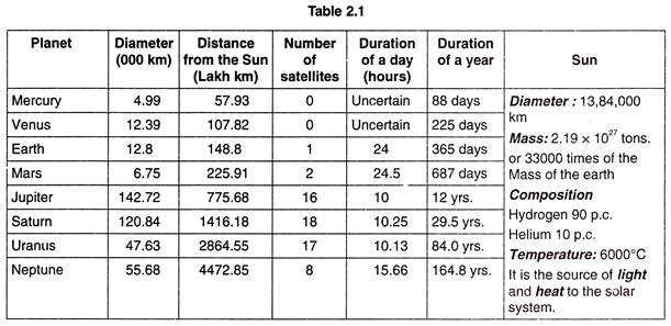
Due to rotation and cooling through radiation, the outer portion became denser and rings were thrown out. In course of time, these rings condensed into planets while the remnant continues as the sun (Table 2.1).
In 1796, Laplace- a great French Mathematician supported the Nebular hypothesis. However, there are several criticisms against Laplace’s theory and the most important one is that rings cannot condense into planets.
Kelvin’s Nuclear clots Hypothesis and Chamberlin and Moulton’s Planetesimal Hypothesis are other two hypotheses relating to the origin of the earth. However, they also lack in certain aspects of acceptability.
Tidal Hypothesis:
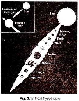
Looking from different angles, the Tidal Hypothesis of Jean and Jeffreys – well-known scientist of England has been found to be more acceptable. According to this hypothesis, the sun was a big and extensive mass of gas moving in space. Once, another much larger star happened to come closer to the sun and due to gravitational pull of this star a tide occurred on the surface of the sun.
As a result, protuberances of material from the sun came out towards the approaching star and in course of time it gave birth to earth and other planets of the solar system (Fig. 2.1).
There are several points in favour of Jean and Jeffreys (Tidal Hypothesis):
(1) If the density of the sun increases from its surface towards the interior, it is quite natural that the protuberances come out from the surface like a filament having lesser density. Naturally, the protuberances produced by the passing star should have been thicker in the middle and thinner at both the ends. The arrangement of the planets in the solar system is also like a cigar-middle portion bigger and tapering towards the two ends.
When the passing star had gone far away, the filament has been broken into pieces and due to the gravitational force of the sun started rotating around the sun. The planets of bigger size in the middle and smaller size towards the two ends can be seen in Fig. 2.2. Mercury is the smallest and nearest to the sun, Jupiter, the largest is in the middle.
(2) The arrangement of the satellites of respective planet also confirms the validity of this hypothesis. Saturn, the second largest planet has the largest number of 18 satellites and Jupiter, the largest planet has 16 satellites. Uranus and Neptune have 17 and 8 satellites respectively.
(3) Lastly, on the basis of this hypothesis it can be seen that bigger planets remained in the gaseous state for a longer time and have helped in formation of more number of satellites than that of the smaller planets which condensed quickly and did not have scope for formation of satellites.
This hypothesis is also known as Hit and Run Hypothesis or Catastrophic Hypothesis or Tidal Action Hypothesis.
Tidal Disruption Theory:
The earth and planets and their satellites were all part of the sun or another sun like star at that time. There are many theories regarding the formation of the solar system and our earth. One is the tidal disruption theory by Jaans and Jeffereys. This theory states that in the beginning sun was hot and in a gaseous state.
A big star moved across, which caused the tidal disruption of hot gas and it left the sun with a revolving arm or a filament of hot gas, like a spiral nebula .The cooling of filament broke up the sun into masses which began to contract toward nuclei forming planets. The gaseous planets and their satellites continued to revolve as they did after the star passed away. Gradual cooling formed liquids and final solids.
The more volatile material of the earth remained in the gaseous state and formed our atmosphere, originally much deeper and of a higher temperature than now. As the atmosphere cooled, the water vapour condensed and formed clouds. As cooling continued, rain fell and oceans formed.
Steady State Theory:
Another theory which can be considered as alternative to the Big Bang Theory is the Steady State Theory. It is propounded by Hoyle. Here, Hoyle propounded that the Universe remained of the same size at any given point of time. However, this theory has been discarded after evidences of expanding universe.
Big Bang Theory:
Another recent and most convincing proposition regarding the origin of the universe including the planet earth is the Big Bang Theory or Expanding Universe Theory. Eduin Hubble provided evidence of expanding universe in 1920. The theory assumes that the universe began from huge mass of atoms called primeval atoms or cosmic eggs having a state of infinite density.
The universe initiated its origin 15 million years ago when a dense mass of material exploded in the so-called big bang. The explosion sent all of the materials of the universe outward in a cosmos that is still expanding. All of the galaxies, planets, asteroids, and other bodies in the universe were formed from the gas and dust of this extraordinary explosion.
This theory was put forward by an astronomer cum priest named George Lamaitre in 1927. It is felt that the expansion of the universe will continue for a long time. After that perhaps the expansion will slow down. At any point of time, if similar condition prevails the stimeval atoms may become active again and another explosion (big bang) may take place.
Although many scientists contributed to the development of this theory, it was George Gamow who coined the term Big Bang in 1946. Gamow with RA Alpher envisaged a high temperature state in the beginning of the universe.
Evolution of the Earth and Life forms:
The evolution of the earth can be described as follows in terms of various stages. In the initial stages the earth was barren, rocky and hot. It had thin layers of hydrogen and helium. During the period of 4000 million years till now the earth had been through several processes and life evolved.
From the top of the atmosphere to the centre of the earth different density materials have formed different layers. The process of separating denser materials from the lighter materials is called differentiation. The present atmosphere contains water vapour, nitrogen, carbon dioxide, methane and small quantity of oxygen. Plants are the major sources of oxygen on earth.
The oceans formed within 500 million years from the formation of the earth. Life began approximately 3000 million years ago. The process of photosynthesis began between 2500 and 3000 million years ago. The first life of the earth was confined to oceans in the form of small bacteria. The evolution of life from bacteria to modern man is shown by Geological Time Scale expressed in terms of Eons, Era, Period and Epoch.
Essay # 7. Numerical Facts about the Earth:
The earth is spherical in shape with a bulge at the middle and a slight flattening at the poles. The equatorial radius is 6374 km and the polar radius is 6357 km. The mean distance from the sun is 150 million km.
Continental Drift Theory:
The making of the continents began 200 million years ago (during the Persian period) with the split of gigantic landmass known as PANGEA. Two continents laurasia to the north and Gondwana to the south were formed. Later on, these were sub divided into smaller parts approximately the shapes of Africa, Eurasia North and South America, Australia and Antarctica as we know today. This theory is known as continental drift theory.
Continents and Oceans of the World:
During Persian period, outer surface of the earth was broken into 10 major and a number of minor sections called plates. It is on these plates that continents rest. The rifts between the plates were filled with molten material from the mantle pushing the plates to either side and farther and farther as the material continued to seep through. Since this material was heavier, it levelled off below sea level forming ocean floors as water from the pacific flowed in.
A continent is a large, continuous area of land on the earth. All continents together constitute less than one-third of the earth’s surface, more than two-third of the earth’s surface are covered with water. Two third of the continental land mass is located in the northern hemisphere.
There is no standard definition for the number of continents in the world. By most standards, there are a maximum of seven continents Africa, Antarctica, Asia, Australia/Oceania, Europe, north America and south America. In Europe, many students are taught about six continents, where north and south America are considered to form one America.
Many geographers and scientists now refer to six continents, where Europe and Asia are combined, called Eurasia, because they are one solid land mass. By the definition of a continent as a large continuous area of land, the pacific islands of Oceania are not a continent, but one could say, they belong to a continent e.g. Oceania is sometimes associated with the continent of Australia.
Essay # 8. Energy Intercepted by the Earth:
Radius of the earth = r
Area of the earth = π r2
Solar constant = S
Total energy intercepted by the earth in unit time = π r2 S
= 6.37 x 10²¹cal day-1
Surface area of the earth = 4 π r2
If this energy is spread uniformly over the full surface of earth, then the energy received per unit area per unit time (QS) can be given as follows:
But the distribution of solar radiation over the earth surface is not uniform, annual value at the equator is 2.4 times that at the poles. Incident solar energy at the surface depends upon geographic location, orientation of the surface, time of the day, time of the year and atmospheric conditions i.e. clear, cloudy, foggy etc..
