ADVERTISEMENTS:
The drainage patterns are divided into the following ten types: 1. Trellised Drainage Pattern 2. Dendritic Drainage Pattern 3. Rectangular Drainage Pattern 4. Radial Drainage Pattern 5. Centripetal Drainage Pattern 6. Annular Drainage Pattern 7. Barbed Drainage Pattern 8. Pinnate Drainage Pattern 9. Herringbone Drainage Pattern 10. Parallel Drainage Pattern.
Type # 1. Trellised Drainage Pattern:
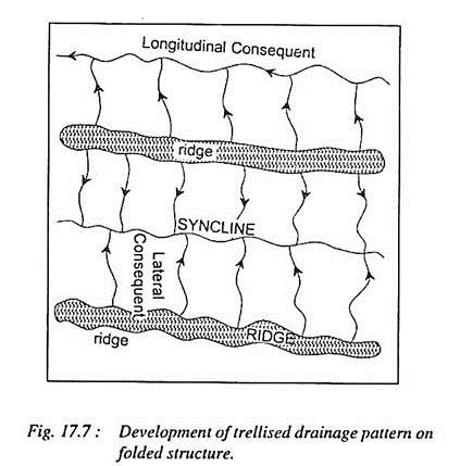
Trellised drainage patterns are formed by the network of tributaries and master consequent streams which follow the regional slope and are well adjusted to the geological structures. Such patterns are developed in the area of simple folds characterised by parallel anticlinal ridges alternated by parallel synclinal valleys. Several master consequent longitudinal streams valleys occupying the furrows between parallel ridges are parallel to each other.
Several streams develop on both the flanks of the ridges and join the longitudinal synclinal streams at right angle. These tributary streams are called as lateral consequent streams. Thus the resultant network of numerous longitudinal streams and transverse or lateral consequents is called trellised pattern.
ADVERTISEMENTS:
This pattern also resembles the rectangular pattern. In fact, the trellised and rectangular patterns are differentiated on the basis of spacing between the streams. If the streams are closely spaced the resultant pattern becomes trellised while rectangular pattern is formed when the streams are widely spaced. Trellised drainage patterns are generally formed in the regions of cuesta topography where hard beds become escarpments and soft beds are eroded to become valleys or lowlands.
Type # 2. Dendritic Drainage Pattern:
Dendritic or tree-shaped drainage pattern is the most common and widespread pattern to be found on the earth’s surface. The pattern is called dendritic on the ground that the network of tributaries of various orders and magnitudes of the trunk or master stream resembles the branches and roots and rootlets of a tree.
The dendritic pattern is associated with the areas of homogeneous lithologies, horizontal or very gently dipping strata, flat and rolling extensive topographic surface having extremely low reliefs. Though dendritic pattern is independent of structural and lithological controls but almost uniform lithology (presence of same type of rocks in extensive area) presents most ideal condition for the development of dendritic drainage pattern.
This pattern develops in a variety of structural and lithological environments such as in the mountainous and hilly areas (e.g., dendritic pattern is one of the dominant patterns in the Himalayas), on extensive plateau surfaces (e.g., Deccan plateau), on peneplain surfaces (e.g., the Peninsular peneplains of India, mostly in the basins of the Mahanadi, the Godavari, the Krishna, the Cauvery, the Domodar etc.), in the alleviated plains (e.g., Great Plains of North India), in the desert plains (e.g., Rajasthan desert), in the glaciated lowland regions (e.g., North European plains and northern lowlands of North America) etc.
ADVERTISEMENTS:
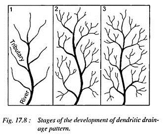
The evolution of dendritic pattern is guided by the lithological characteristics mainly the permeability of underlying rocks, the amount and regime of rainfall and resultant surface runoff and the time factor. First of all the master or trunk consequent stream develops on gently sloping topographic surface.
The master consequent gradually but slowly lengthens its longitudinal course through headward erosion. Major tributary streams of the master stream develop on either side of the trunk stream (fig. 17.8).
These tributaries also lengthen their longitudinal courses through headward erosion and branches of tributaries are developed in due course of time [fig. 17.8 (2)]. In the beginning the dendritic pattern is ‘open’ because the streams are few in number and are widely spaced [fig. 17.8 (1)] but with the passage of time a dense mesh of multitudes of tributaries of various hierarchical orders is developed and thus the initial open network becomes a ‘closed pattern’ as the streams are very closely spaced.
ADVERTISEMENTS:
At a much later date, i.e., in the penultimate stage of drainage development, the dendritic pattern becomes ‘simplified’ due to ‘surface abstraction’ because many of the tributaries are integrated due to active river capture.
Slope and permeability of rocks very effectively control the number and extension of streams of dendritic drainage pattern. The drainage network of dendritic pattern becomes most extensive if the land surface is characterized by flat surface, level to gentle slopes and impermeable rocks.
In such environmental conditions the pattern extends both in length and width but if the region is characterized by higher slope angles, the pattern extends more in length than in width. The extensive plateau surfaces of the Panna plateau, Bhander plateau and Rewa plateau (M.P.) composed of sandstones capping and the peneplained surface of the central Ranchi plateau composed of granite-gneisses have favoured extensive dendritic drainage pattern while elongated dendritic pattern has developed along the middle and lower segments of the escarpments associated with these plateaux.
Type # 3. Rectangular Drainage Pattern:
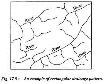
Rectangular pattern shows some degree of resemblance to trellised drainage pattern as tributary streams in both the patterns join their master streams almost at right angle but the confluence angle in the trellised pattern is guided by the strikes and dip angle of the rock beds while it is determined by the lines of weaknesses (e.g. faults and fractures and joints) of the rocks in the rectangular pattern.
The second line of difference between these two drainage patterns is related to the spacing of streams i.e. the rectangular pattern is characterized by widely spaced trbutaries while trellised pattern has a dense mesh of closely spaced tributaries.
Rectangular pattern is generally developed in the regions where the rock joints form rectangular pattern. The rocks are weathered and eroded along the interfaces of joints, fractures and faults and thus surface runoff collects in such long and narrow clefts (resulting from the weathering and erosion of joints) and forms numerous small rills.
These rills are further extended in length and width and become channels. With the march of time a network of streams is developed wherein streams follow the lines of weakness (joints and fractures). The tributaries join their master streams almost at right angles and thus a rectangular drainage pattern is formed (fig. 17.9).
Type # 4. Radial Drainage Pattern:
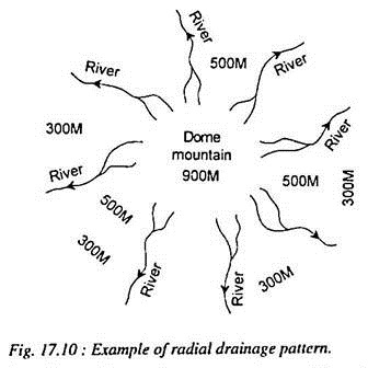
Radial drainage pattern, also known as centrifugal pattern, is formed by the streams which diverge from a central higher point in all directions. It is obvious that dome structures, volcanic cones, batholiths and laccoliths, residual hills, small tablelands, mesas and buttes, and isolated uplands favour the development of ideal radial pattern (fig. 17.10).
The streams emerge at the central point of the aforesaid reliefs and drain down the slopes in all directions. Since the streams follow the slopes and hence they are basically consequent streams. These streams resemble the spokes of a wheel or the radii of a circle. If we take the entire drainage network of Sri Lanka, it exhibits the best example of radial drainage pattern at macro-level. The local upland situated to the south-west of Ranchi city has given birth to radial drainage pattern wherein the South Koel, the Subarnarekha, the Kanchi and the Karo rivers take their sources and radiate in different directions.
Hazaribagh plateau, Parasnath hill, Panchet hill and Dalma lava upland (all in Jharkhand) have issued radial drainage pattern. Morcha pahar and Lugu hill of Hazaribagh, Mt. Abu (Rajasthan) etc. present ideal examples of radial drainage pattern. At a regional level the Rohtas plateau of S.W. Bihar province presents a good example of radial drainage pattern wherein the Karamnasa and the Durgawati rivers and their source tributaries emerge from the south-western corner of the plateau and flow in the western, north-western, northern, and north-eastern directions whereas the tributaries of the Son River flow in the southern direction.
Type # 5. Centripetal Drainage Pattern:
Centripetal or inland drainage pattern (fig. 17.11) is opposite to the radial drainage pattern because it is characterized by the streams which converge at a point which is generally a depression or a basin. This pattern is formed by a series of streams which after emerging from surrounding uplands converge in a central low land which may be a depression, or a basin or a crater lake.
The Kathmandu valley of Nepal presents an ideal example of centripetal drainage pattern wherein the tributary streams of the Baghmati converge in the tectonically formed circular basin. The depression formed at the top of Raigarh Dome in the Lower Chambal Basin has given birth to centripetal drainage pattern.
Type # 6. Annular Drainage Pattern:
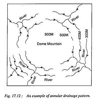
Annular pattern, also known as ‘circular pattern’ is formed when the tributaries of the master consequent streams are developed in the form of a circle. Such pattern (fig. 17.12) is developed over a mature and dissected dome mountain characterised by a series of alternate bands of hard and soft rock beds.
The differential erosion of hard and soft rock beds results in the truncation of the beds which produces ringed belted structure wherein relatively resistant beds project outward whereas the weaker (soft) beds form circular clefts.
The master consequent streams emerge at the top of the dome and rediate in all directions down the slope like radial drainage pattern whereas tributary streams develop in the clefts formed due to erosion of soft beds, assume actuate shape and join the master consequent streams and thus annular drainage pattern is formed. At a much later date tributaries of circular subsequent streams, which join the radial consequents, are also developed and thus the drainage pattern becomes a special case of trellised pattern. Annular drainage pattern has developed over denuded domes in the Weald of England. The mature dissected Sonapet dome of Uttaranchal presents an ideal example of annular drainage pattern.
Type # 7. Barbed Drainage Pattern:
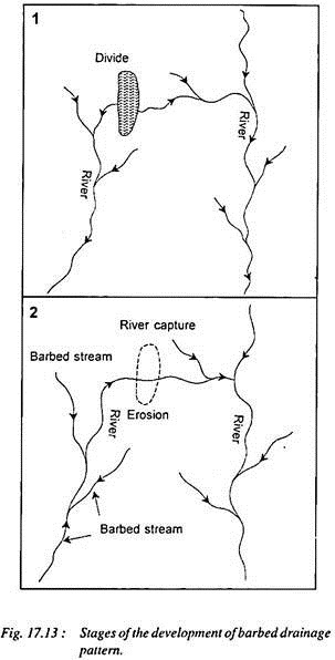
Barbed drainage pattern, a rare kind of drainage pattern, is formed when the tributaries flow in opposite direction to their master streams. The tributaries join their master streams in a hook-shaped bend. Such pattern is generally developed due to river capture (fig 17.13).
Type # 8. Pinnate Drainage Pattern:
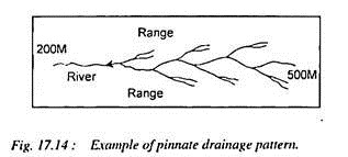
Pinnate pattern is developed in a narrow valley flanked by steep ranges. The tributaries originating from the steep sides of parallel ridges join the longtitudinal master consequent occupying the valley at acute angles (fig. 17.14). The drainage network of the upper Son and Narmada rivers denotes the example of pinnate drainage pattern. This pattern resembles the veins of a leaf.
Type # 9. Herringbone Drainage Pattern:
Herringbone drainage pattern, also known as rib pattern (like the rib bones of human beings), is developed in mountainous areas where broad valleys are flanked by parallel ridges having steep hillside slopes.
The longitudinal consequent streams, as master streams, are developed in the longitudinal parallel valleys while tributaries, as lateral consequents, after originating from the hillslopes of the bordering parallel ridges join the longitudinal consequents almost at right angle.
The courses of the tributaries are straightened because of slope factor and little distance between the ridges and the longitudinal consequents occupying the valleys and thus the tributaries are not allowed to adapt sinuous course and join the longitudinal consequents at acute angles (fig. 17.15). The term herringbone has been derived from the pattern of bones of herring fish (mainly spine bones).
The upper Jhelum River in the Vale of Kashmir receives numerous tributaries from both the sides and thus forms herringbone drainage pattern. The rivers occupying east-west trenches in the Himalayas form herringbone pattern. The Tamar Kosi, a left bank tributary of the Kosi River, the upper Rapti (a tributary of the Ghaghra River), the Rapti (another one), the left bank tributary of the Gandak River etc. have formed such drainage pattern.
Type # 10. Parallel Drainage Pattern:
Parallel drainage pattern comprises numerous rivers which are parallel to each other and follow the regional slope. This pattern is more frequently developed on uniformly sloping and dipping rock beds such as cuestas or newly emerged coastal plains.
The western coastal plains of India represent several examples of parallel drainage patterns where the streams after taking their sources from the western flanks of the Western Ghats drain in straight courses towards west to empty into the Arabian Sea. Parallel drainage pattern has also developed on the Eastern Coastal Plains of India. It may be pointed out that a sub-parallel pattern is, therefore, essentially an ‘initial drainage pattern’ (fig. 17.16).

