ADVERTISEMENTS:
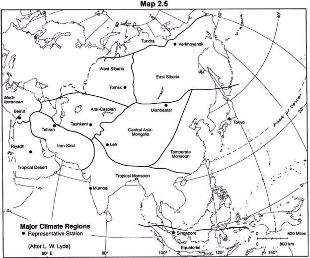
Some of the major climatic regions of Asia are as follows: 1. Tundra Region 2. East Siberia 3. West Siberia 4. Temperate Monsoon Lands of East Asia 5. Tropical Monsoon Region 6. Equatorial Region 7. Central Asia: Mongolian Region 8. Central Asia: Aral-Caspian Region 9. Iran-Sind Region 10. Mediterranean Region 11. Tropical Desert Region.
The large variety of climates that prevail in Asia may be grouped into several broad regional types. The regional division adopted here is a modification of Lyde’s classification (Lyde, 1938, pp. 125-139). Unlike Koppen and Thornthwaite who apply the statistical variables in delineating the climatic boundaries, but largely ignore the important “dominant controls” in patterning climates, particularly that of relief, and pressure and wind systems, the basis of classification adopted here is “genetic” rather than statistical, and hence the climatic boundaries are generalized rather than precise.
1. Tundra Region:
It spans the entire continent from east to west along the Arctic Ocean and includes the lowlands between the Arctic Circle and 70°N, the southern limits roughly coincide with the July isotherm of 50°F (10°C). Winters are long, dry and snowbound; summers are short but warm enough for some snow to melt. The snow cover, usually not thick due to scarcity of precipitation, allows the subsoil to be deeply frozen during winter; soil surface thaws are possible only in summer, when the surface becomes swampy.
2. East Siberia:
ADVERTISEMENTS:
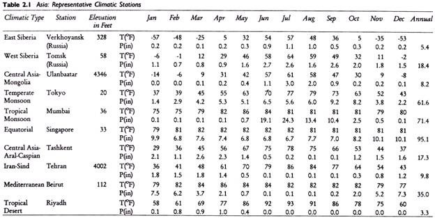
Between 50° and 70°N latitudes a large territory in eastern Siberia including the lower basin of Lena river and the area to the north of Baikal lake. It is mostly a mountainous region (Yablonoi, Stanovoi, Verkhoyansk mountains). The deep interior location and the sheltering mountains rob the region of the influences of the Pacific and the Atlantic Oceans. The winters are long, dry and among the coldest in the world. Verkhoyansk has once recorded -80°F. The summers are warm with temperatures varying between 50°F and 70°F (20°C).
Given these extremes, the world’s largest temperature ranges are found (up to 50°C at several stations). The region thus epitomizes the cold, continental climate. In the Kamachatka peninsula, the moderating influence of the Pacific keeps the temperature somewhat higher in winter and lower in summer.
3. West Siberia:
The region is located west of the preceding region all the way to the Ural Mountains. Temperatures are higher than in East Siberia, and there is a little more rainfall (up to 250 mm annually)—a clear evidence of the Pacific influence. The ground remains frozen in winters, and thaws during the brief summer, causing swamps and marshes.
4. Temperate Monsoon Lands of East Asia:
Most of eastern China, North Korea, South Korea, and Japan are included in this region which lies entirely north of the Tropic of Cancer. Summers get rainfall, and winters are dry—a definite monsoonal trait. Only Taiwan, and southern islands of Japan including southern half of Honshu, receive rainfall in winter caused by the southeasterly winds which bring rainfall after picking up moisture on the Japan Sea, East China Sea, and the adjoining seas. The range of temperature increases in the interiors, as the winters become colder and summers warmer.
5. Tropical Monsoon Region:
It is a vast region in southern and southeastern Asia encompassing nearly all the territory north of 10° north and south of the Tropic of Cancer—from the Indus-Ganga lowlands to the Indo-Chinese peninsula (Vietnam, Cambodia, Laos) and Myanmar and Thailand.
ADVERTISEMENTS:
The North Indian plains are practically tropical in climate although they actually lie in the Temperate Zone. Typically monsoonal conditions—seasonal reversal of wind systems and associated rainfall regimes—prevail.
It is important to emphasize here that the summer monsoons in India owe their origin to the pressure and wind systems in the equatorial zone. During summer the southeast winds are sucked to the low-pressure area in western India and the moist winds from the Indian Ocean cause the onset of rain bearing summer monsoons.
Most of the region, from India to China and Japan, receives rainfall during summer months. In winter, conditions are reversed. Winds low from the high-pressure region of East Siberia outward and are dry. However, during their course as they traverse the wafers of East and South China seas, they pick up moisture and bring some rain to parts of East Asia and Southeast Asia that lie in their tracks (southern China coast North Vietnam, northeastern Sri Lanka, southern part of east coast of India).
The countries of the Indo-Chinese peninsula (Vietnam, Laos, and Cambodia) reflect monsoonal seasonality but differ from the Indian and Chinese monsoons. The range of temperature is smaller and the seasonality of rainfall depends on the precise locations with reference to the summer or winter monsoons.
6. Equatorial Region:
It includes the areas lying between 10°N and 10°S in Indonesia and Malaysia. Typical climatic conditions consist of high, seasonally well- distributed rainfall and a small range of temperature except in locations where the seasonal shifting of the trade winds leaves a part of the year relatively drier.
7. Central Asia: Mongolian Region:
The region lies in the heart of the continent containing a vast territory of mountains, and plateaus from Tibet to Mongolia. The conspicuous climatic characteristics are extreme temperature ranges (daily and annual) and dryness. The region comes under the influence of a large body of cold, continental, and out flowing dry winds over Asia’s landmass. In summer, the landmass is heated, and a low pressure system takes over, with the consequent dry, inflowing, gusty winds, the enclosing mountain system shelters this vast region from the inflow of any maritime winds.
8. Central Asia: Aral-Caspian Region:
The region resembles the Iran-Sind region (described below) in dryness and large temperature ranges, but differs in topography, as it is mostly lowland drained by the historic Amu and Syr rivers. The Mediterranean influences (some winter rain) reach the western section; but the eastern part gets most rainfall during the summer. Irrigation is important for all cultivation, as rainfall is scanty.
9. Iran-Sind Region:
The region includes eastern Iran, Afghanistan, and southern Pakistan (Sind province). Dryness and heat are the two outstanding characteristics of the climate. Rainfall increases somewhat from the Iran plateau with nearness to the sea. Very hot summers and cold winters account for large temperature ranges.
Toward the east, monsoonal traits (summer precipitation) are becoming increasingly evident; in the western parts Mediterranean influences are evident.
10. Mediterranean Region:
Climatically, the region is transitional between the trade wind deserts (Arabia) and the zone of prevailing westerlies. It includes the territory bordering the Mediterranean from Turkey to Syria, Israel, and Iraq. Winter temperatures fall below 50°F and in summer rise above 75°F. Precipitation is mostly in winter brought by the cyclonic storms emanating in the west.
11. Tropical Desert Region:
The region lies essentially in the trade wind belt, outside the monsoonal and Mediterranean influences. Excessive temperature ranges and dryness characterize the climate.


