ADVERTISEMENTS:
After reading this article you will learn about the classification of landforms.
A little attention to the form of the earth’s surface shows that it has two parts—oceans and continents. Of the earth’s surface, an area of 148 million square km, i.e., 2/7th part, is covered by land and the remaining 361 million sq km, i.e., 5/7th part is covered by oceans.
In terms of origin, oceans and continents have certain differences. Generally, the materials which constitute the ocean bottom are harder and heavier than those which constitute the continents. Though the interior of the earth is still in a hot and molten state, it is still undergoing contraction.
The contractions could be slow or sudden. Whether slow or sudden, the contractions are continuously altering the form of the earth’s surface. Such changes on the earth’s surface are therefore caused by the actions of internal force.
Since the very beginning of the earth, its surface has been continuously subjected to change by the action of river, glaciers, winds, sea waves, earthquakes, etc. Such changes are, therefore, caused by the actions of external force.
On the land surface around us, we find hills and mountains, plateaus, plains, deserts, islands, etc. All these are formed by the actions of internal and external forces. Likewise, the same forces cause continental shelves, shores, deep sea floor, trench and submarine plateaus, in the oceans. The various forms of the earth’s surface have intimate bearing upon man’s life on the earth.
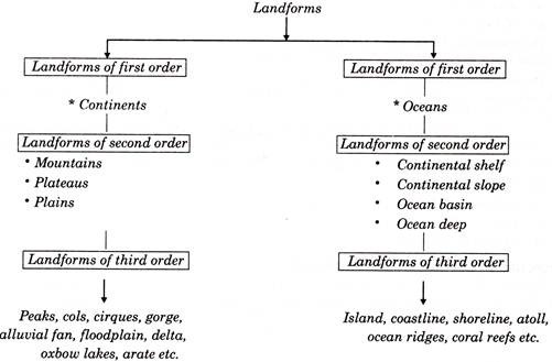
These landforms are outlined below:
By the actions of internal forces anticlines and synclines were formed and in course of time these have been identified as continents and oceans. That is why, they are called as Landforms of First Order or Primary landforms.
ADVERTISEMENTS:
The continental landforms consist of Americas, Eurasia, Africa, Australia and Antarctica. The total area is nearly 148 million sq km, i.e., 28 per cent of the earth’s surface and average height is 830 metres.
The major landforms of the continents are:
(a) Mountain belts
ADVERTISEMENTS:
(b) Old stable shields.
The mountain belts include—the Himalayas, the Alps, the Rockies, the Andes, the Caucasus and the Eastern Indian mountain ranges.
The old shields of the world are—Canadian, Baltic, Brazil, Siberian (Angara), Gondwana, Australia, South Africa, Antarctica and China Shields. All the plateaus of the continents are located in these shields.
The oceans occupy 361 million sq km (72 per cent of the earth’s surface) and have average depth of 4-6 thousand metres. Therefore, it is seen that the average depth of the oceans is much more than the average heights of the continents.
The landforms of the ocean floor consist of:
(a) Continental shelf
(b) Continental slope
(c) Deep sea floor
(d) Trench or canyons.
ADVERTISEMENTS:
Landforms of Second Order: Continents:
The plateaus, mountains, plains and extensive deserts of the continents are the example of the landforms of second order on the continents.
Broadly, these landforms are grouped into:
(i) Hills and mountains
(ii) Plateaus
(iii) Plains.
(i) Hills and Mountains:
Hills and mountains are high and lofty masses covering large areas of the earth’s surface. There is no basic difference between hills and mountains. Raised masses that are higher than 900 metres are called mountains and that are less than 900 metres are called hills. The actions of internal and external forces can lead to the formation of hills or mountains. Hills and mountains can be divided into four major types.
They are:
(a) Fold mountain,
(b) Block mountain,
(c) Mountain of accumulation, and
(d) Residual mountain.
(ii) Plateaus:
A plateau is an extensive level or almost level elevated land. There is often a difference between a mountain or a hill and a plateau. A plateau is a large elevated rolling ground whereas a mountain or a hill has peaks with steep slopes.
It may be formed by many ways. Some plateaus had their origin in the beginning of the earth. The plateau of Peninsular India, some parts of Africa, the north-eastern part of Canada, parts of Brazil, Siberian Plateau and the West Australian Plateau are the examples of this kind.
Earth movement and wearing of rock materials are the two principal causes for the formation of plateaus.
At the time of earth movement some parts of the earth rise up to form highlands of different elevations. Among these the flat-topped stretches of highland are known as plateaus. Such plateaus are often surrounded by mountains and other highlands.
These are called intermountane plateaus (Latin: inter-between, mons-mountains). The flat topped part of a plateau is also known as table land. Very large parts of Tibet, Rockies and Andes consist of many intermountane plateaus.
Sometimes earth movement may raise a large depressed area to a considerable height above sea-level to form plateaus. Such plateaus are called continental plateaus. The examples of such plateaus are Chota Nagpur, Meghalaya, Kaimur, Rohtas, Ranchi, Mysore.
Accumulation of lava thrown out by volcanoes onto the surface may be built up into volcanic plateaus. Maetwa plateau of India and Colombia plateau of U.S.A. are the good examples of such plateaus.
The old mountains are generally worn away to form plateau. As soon as a stretch of highland is formed, the various agents of erosion begin to wear it away. Generally the soft rocks are worn away quickly and the harder ones are removed very slowly.
Eventually, the whole region is seen to be worn into a series of highlands and valleys. Such an area is known as dissected plateau. The Western Ghat mountain of India consists of such dissected plateaus.
There are many plateaus in the world. Most of them are found in Africa and Asia. The Tibet is the largest and the Pamir is the highest plateaus in the world. Some big and small plateaus are also seen in other continents.
(iii) Plains:
Relatively flat, featureless and extensive lowland is called plains. Plains are generally level, but sometimes they may be slightly rolling or undulating. An extensive plain consists usually of low valleys separated by low hills. Such a plain is known as a rolling undulating plain. Plains may be formed in many ways.
They are often classified into three main groups according to the way in which they have been formed:
(а) Erosional plain,
(b) Depositional plain, and
(c) Uplifted and Downtilted or Basin plain.
Broadly, according to the location and process of origin, plains may be classified as follows:
The continental shelf, continental slope, deep sea floors and trenches or canyons belong to landforms of second order at the ocean floor. The ocean floor from the coastal portion of the continents up to an average depth of 185 metres is generally known as the continental shelf. It is composed of continental rocks and has a very gentle slope.
At the edge of the continental shelf the seaward slope becomes very steep. This steep slope up to a depth of about 3550 metres is known as continental slope. The angle of slope varies from 2-5 degrees and it covers nearly 8.5 per cent of the sea floor. At an average depth of 3350-5500 metres, between the continental slope and mid-ocean lies the deep sea floor.
It occupies nearly 66 per cent of the ocean floor. The deep sea floor is not plain it is the store house of oceanic deposits. In certain portion of the deep sea floor, there lies very deep trench or canyons. Trenches are generally 5500-10000 metres deep.
Landform of Third Order:
Various features which are generally smaller parts of second order landforms or which form on the second order landforms are known as landforms of third order. There are innumerable such landforms over the continents and at the sea floor.
Peaks, cols, cirques, gorge, morains, alluvial fans, floodplains, ox-bow lakes, levees, deltas, ocean islands, volcanoes and ridges are some of the many features of third order landforms. The details will be mentioned in the subsequent discussions on changes of the earth’s crust: process and agents.
Significance of Landforms to Man:
Landforms have intimate relationship with mankind. The significance of each of the landforms to settlement, ways of living, social structure, clothing, etc., is far-reaching and very important. The mountains have been found to be protecting man from invasion, separating one civilization from other and restricting or encouraging the movement of goods and people.
Aryan civilization has found its way from the central Europe to as far as India through the mountain passes of the Hindukush and the Himalayas. Similarly, the whole India might have experienced extreme climate of either hot or cold if the great Himalayas would not have existed on the northern boundary. This mountain has been able to separate two distinct civilizations—Aryan and Chinese till today.
From economic point of view, even though mountains are not suitable for agricultural purposes, they provide opportunities for growing of fruits and for developing centres of tourist attractions.
On the other hand, plateau regions are rich in agriculture, minerals and they become suitable locations for production of hydel power. For long, the higher parts of the plateaus of the tropical regions of India, Africa and Brazil have provided coolness and generally become the places of summer residences. Some of the plateau regions of the world are famous for plantation agriculture.
The plains of tropical and temperate regions of the world are the homes of the two-thirds of the world population. The plains have got advantages of flat surface, deep and fertile soil, easy means of communication and transport, plenty of cheap labour, raw materials and consumer markets.
These areas are rich in agriculture. Easier movement of people makes the plains the centre of civilization. But, the plains also face serious problems of flood, population explosion and invasions in the course of history.


